IMAGES TAKEN NEAR TO
Stanley Street, BLACKWOOD, NP12 1PT
Introduction
This page details the photographs taken nearby to Stanley Street, NP12 1PT by members of the Geograph project.
The Geograph project started in 2005 with the aim of publishing, organising and preserving representative images for every square kilometre of Great Britain, Ireland and the Isle of Man.

There are currently over 7.5m images from over14,400 individuals and you can help contribute to the project by visiting https://www.geograph.org.uk
Image Map
Images are licensed for reuse under creativecommons.org/licenses/by-sa/2.0
Notes
- Clicking on the map will re-center to the selected point.
- The higher the marker number, the further away the image location is from the centre of the postcode.
Image Listing (256 Images Found)
Images are licensed for reuse under creativecommons.org/licenses/by-sa/2.0
Image
Details
Distance
1
The Little Theatre, Cefn Road, Blackwood
Image: © Roger Cornfoot
Taken: 10 May 2007
0.03 miles
2
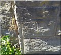
Ordnance Survey Cut Mark
This OS cut mark can be found on the wall post of the Baptist Chapel. It marks a point 181.307m above mean sea level.
Image: © Adrian Dust
Taken: 22 Jun 2019
0.04 miles
3
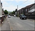
Down Cefn Road, Blackwood
Cefn Road descends towards the town centre. Viewed from the corner of South View Road.
Image: © Jaggery
Taken: 17 May 2018
0.05 miles
4
Wesley Road, Blackwood
Dead-end road above the west side of High Street.
Image: © Jaggery
Taken: 17 May 2018
0.05 miles
6
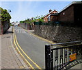
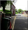
No Parking at the southern end of Cefn Road, Blackwood
Double yellow lines on both sides of Cefn Road indicate no parking at any time.
Image: © Jaggery
Taken: 17 May 2018
0.07 miles
7
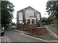
Central Methodist Church, Blackwood
Located on the corner of Wesley Road (on the left) and Cefn Road, viewed from High Street.
Image: © Jaggery
Taken: 1 Mar 2010
0.08 miles
8
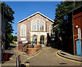
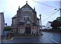
Blackwood Methodist Church, Blackwood
The Wesley Road church is set back 45 metres from the west side of High Street.
The church is part of the Gwent Hills and Vales Methodist Circuit.
Image: © Jaggery
Taken: 15 Aug 2016
0.08 miles
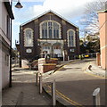
9
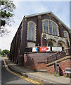
Southeast corner of Blackwood Methodist Church
Viewed from Wesley Road. In 2018 the church is part of the Gwent Hills and Vales Methodist Circuit.
The building in the Subclassical and Simple Gothic style dates from 1898.
Image: © Jaggery
Taken: 17 May 2018
0.08 miles
10
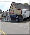
Vacant premises, Pentwyn Road, Blackwood
A Paul Fosh Auctions Sold board is on the wall of the vacant premises in May 2018.
An August 2011 Google Earth Street View shows Tydfil Training here.
The entrance to Black Sheep music, social and events hub is at the right edge of the photo.
Image: © Jaggery
Taken: 17 May 2018
0.08 miles