IMAGES TAKEN NEAR TO
Derwen Close, Cefn Road, BLACKWOOD, NP12 1JD
Introduction
This page details the photographs taken nearby to Derwen Close, Cefn Road, NP12 1JD by members of the Geograph project.
The Geograph project started in 2005 with the aim of publishing, organising and preserving representative images for every square kilometre of Great Britain, Ireland and the Isle of Man.

There are currently over 7.5m images from over14,400 individuals and you can help contribute to the project by visiting https://www.geograph.org.uk
Image Map
Images are licensed for reuse under creativecommons.org/licenses/by-sa/2.0
Notes
- Clicking on the map will re-center to the selected point.
- The higher the marker number, the further away the image location is from the centre of the postcode.
Image Listing (72 Images Found)
Images are licensed for reuse under creativecommons.org/licenses/by-sa/2.0
Image
Details
Distance
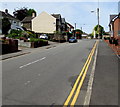
1
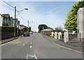
Pentwyn Road past Blackwood War Memorial
Pentwyn Road ascends towards Lewis Lewis Avenue. Lewis Lewis (also known as Lewsyn yr Heliwr) was one of the 26 people arrested and put on trial for taking part in the Merthyr Rising of 1831. Originally sentenced to hang, his sentence was downgraded to a life sentence and penal transportation to Australia when one of the police officers who had tried to disperse the crowd testified that Lewis Lewis had tried to shield him from the rioters. Lewis Lewis was transported in 1832. He died in Port Macquarie in 1847.
Blackwood War Memorial is on the right. https://www.geograph.org.uk/photo/5778234
Image: © Jaggery
Taken: 17 May 2018
0.06 miles
2
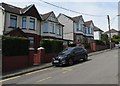
Pentwyn Road semis, Blackwood
Semi-detached houses on the west side of Pentwyn Road.
Image: © Jaggery
Taken: 17 May 2018
0.06 miles
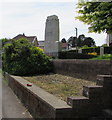
3
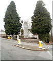
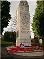
War memorial, Blackwood
Located at the top of a flight of steps on the corner of Pentwyn Avenue and Pentwyn Road. The Memorial was unveiled in 1926. Grade II listed in 2002.
Image: © Jaggery
Taken: 17 Jan 2011
0.07 miles
4
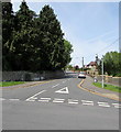
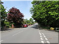
Up Cefn Road, Blackwood
Cefn Road ascends towards the Cefn Fforest area of Blackwood.
Image: © Jaggery
Taken: 17 May 2018
0.09 miles
5
Up Pentwyn Road, Blackwood
Pentwyn Road ascends towards Blackwood War Memorial https://www.geograph.org.uk/photo/5778234 in the background.
Image: © Jaggery
Taken: 17 May 2018
0.10 miles
6
East side of Blackwood War Memorial
Viewed from Pentwyn Avenue. https://www.geograph.org.uk/photo/5778234 to the south side and some details.
Image: © Jaggery
Taken: 17 May 2018
0.10 miles
7
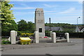
West side of Blackwood War Memorial
Viewed across Pentwyn Road. The design of the Memorial was influenced by Lutyens' Cenotaph https://www.geograph.org.uk/photo/3176066 in Whitehall, Westminster. Blackwood War Memorial was unveiled in 1926, Grade II listed in 2002. https://www.geograph.org.uk/photo/5778234 to the south side.
Image: © Jaggery
Taken: 17 May 2018
0.10 miles
8
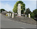
Grade II listed Blackwood War Memorial
Located above the corner of Pentwyn Road and Pentwyn Avenue. The design of the Memorial was influenced by Lutyens' Cenotaph https://www.geograph.org.uk/photo/3176066 in Whitehall, Westminster. Blackwood War Memorial was unveiled in 1926, Grade II listed in 2002. The inscription on the side in view is TO THE MEMORY OF THE MEN OF THIS TOWN WHO FELL SERVING THEIR COUNTRY 1914-1918 1939-1945.
Image: © Jaggery
Taken: 17 May 2018
0.10 miles
9
Blackwood Cenotaph
Blackwood Cenotaph is partly modelled on the Whitehall Cenotaph and the scene of a well attended annual Remembrance Day Service
Image: © Reginald Brown
Taken: 14 Nov 2009
0.10 miles
10
North along Pentwyn Avenue, Blackwood
Towards Sunnybank Road. The Pentwyn Court junction https://www.geograph.org.uk/photo/5778176 is on the right.
Image: © Jaggery
Taken: 17 May 2018
0.10 miles