IMAGES TAKEN NEAR TO
Pentwyn Road, BLACKWOOD, NP12 1HN
Introduction
This page details the photographs taken nearby to Pentwyn Road, NP12 1HN by members of the Geograph project.
The Geograph project started in 2005 with the aim of publishing, organising and preserving representative images for every square kilometre of Great Britain, Ireland and the Isle of Man.

There are currently over 7.5m images from over14,400 individuals and you can help contribute to the project by visiting https://www.geograph.org.uk
Image Map
Images are licensed for reuse under creativecommons.org/licenses/by-sa/2.0
Notes
- Clicking on the map will re-center to the selected point.
- The higher the marker number, the further away the image location is from the centre of the postcode.
Image Listing (193 Images Found)
Images are licensed for reuse under creativecommons.org/licenses/by-sa/2.0
Image
Details
Distance
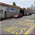
1
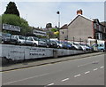
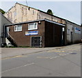
Select Car Sales, Blackwood
Above the west side of Pentwyn Road.
Image: © Jaggery
Taken: 17 May 2018
0.01 miles
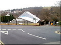
2
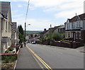
Down Pentwyn Road, Blackwood
Pentwyn Road descends towards High Street, viewed in May 2018.
Recently-built houses on the left are on the site of a demolished school.
Image: © Jaggery
Taken: 17 May 2018
0.01 miles
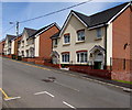
3
Old School Place, Blackwood
Recently-built houses on the site of a demolished school. Viewed across Pentwyn Road in May 2018.
Image: © Jaggery
Taken: 17 May 2018
0.02 miles
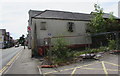
4
D & E Motors, Pentwyn Road, Blackwood
Text on the name sign in May 2018 includes Full Servicing - Repairs -
Air Conditioning - Brakes - Clutches - Timing Belts - Diagnostics.
Image: © Jaggery
Taken: 17 May 2018
0.03 miles
5
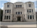
Moose Hall, Blackwood
Moose International's Blackwood Lodge No. 11 is set below road level on the east side of Pentwyn Road. Viewed from the edge of South View Road.
First established in Great Britain in 1926, Moose International is a fraternal service organisation, who look after their own members and give support to others less fortunate than themselves. It is non-political and non-denominational.
Image: © Jaggery
Taken: 17 Jan 2011
0.03 miles
6
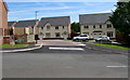
Recently-built houses on the east side of Pentwyn Road, Blackwood
On the site of a demolished school. Viewed in May 2018.
Image: © Jaggery
Taken: 17 May 2018
0.04 miles
7
Fenced-off former Red Lion, High Street, Blackwood
Viewed in May 2018. A notice states that planning permission was given on July 26th 2017 for the demolition of the Red Lion Inn and the residential development of the site for seventeen apartments.
Image: © Jaggery
Taken: 17 May 2018
0.04 miles
8
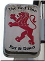
Red Lion name sign, High Street, Blackwood
Located here. https://www.geograph.org.uk/photo/5777822
Image: © Jaggery
Taken: 17 May 2018
0.04 miles
9
Rhyd Developments Ltd name sign, Pentwyn Road, Blackwood
The name sign is on the wall near steps leading up to a door on the west side of Pentwyn Road in May 2018.
Image: © Jaggery
Taken: 17 May 2018
0.04 miles