IMAGES TAKEN NEAR TO
Cardigan Way, BLACKWOOD, NP12 1GB
Introduction
This page details the photographs taken nearby to Cardigan Way, NP12 1GB by members of the Geograph project.
The Geograph project started in 2005 with the aim of publishing, organising and preserving representative images for every square kilometre of Great Britain, Ireland and the Isle of Man.

There are currently over 7.5m images from over14,400 individuals and you can help contribute to the project by visiting https://www.geograph.org.uk
Image Map
Images are licensed for reuse under creativecommons.org/licenses/by-sa/2.0
Notes
- Clicking on the map will re-center to the selected point.
- The higher the marker number, the further away the image location is from the centre of the postcode.
Image Listing (5 Images Found)
Images are licensed for reuse under creativecommons.org/licenses/by-sa/2.0
Image
Details
Distance
1
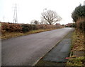
Heol Pit-y-Ceiliogod, Cefn Fforest, Blackwood
Viewed from the corner of Bedwellty Road, looking towards houses at the NW edge of Blackwood.
Image: © Jaggery
Taken: 17 Jan 2011
0.17 miles
2
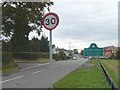
Entering Cefn Fforest
Cefn Fforest is situated on the ridge between the Sirhowy and Rhymney valleys. Approaching from Bedwellty the scenery changes abruptly from farmland to housing estates.
Image: © Robin Drayton
Taken: 27 Sep 2007
0.24 miles
3
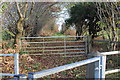
Byway from Heol y Cefn
Start of a grassy track to Heol Pit-y-Ceilogod from Heol y Cefn.
Image: © M J Roscoe
Taken: 23 Nov 2016
0.24 miles
4
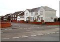
Beaumaris Way, Cefn Fforest, Blackwood
Beaumaris Way houses viewed across Greenwood Road.
Image: © Jaggery
Taken: 17 Jan 2011
0.24 miles
5
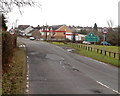
Northern edge of Cefn Fforest, Blackwood
The view along Heol y Cefn on the approach to the boundary of Cefn Fforest, a district in the north of Blackwood. Ahead, Heol y Cefn is renamed Bedwellty Road.
Image: © Jaggery
Taken: 17 Jan 2011
0.25 miles