IMAGES TAKEN NEAR TO
Y Cedrwydden, BLACKWOOD, NP12 1FD
Introduction
This page details the photographs taken nearby to Y Cedrwydden, NP12 1FD by members of the Geograph project.
The Geograph project started in 2005 with the aim of publishing, organising and preserving representative images for every square kilometre of Great Britain, Ireland and the Isle of Man.

There are currently over 7.5m images from over14,400 individuals and you can help contribute to the project by visiting https://www.geograph.org.uk
Image Map
Images are licensed for reuse under creativecommons.org/licenses/by-sa/2.0
Notes
- Clicking on the map will re-center to the selected point.
- The higher the marker number, the further away the image location is from the centre of the postcode.
Image Listing (17 Images Found)
Images are licensed for reuse under creativecommons.org/licenses/by-sa/2.0
Image
Details
Distance
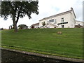
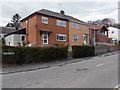
5
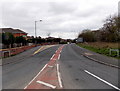
Western end of Highfields Way, Blackwood
Highfields Way heads away from the roundabout at the Bryn Road junction.
Image: © Jaggery
Taken: 3 May 2013
0.16 miles
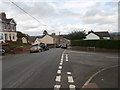
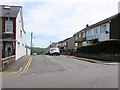
7
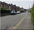
Up Gordon Road, Blackwood
Looking to the WSW up Gordon Road from the corner of Coronation Road.
The Albany Road junction is on the right.
Image: © Jaggery
Taken: 17 May 2018
0.19 miles
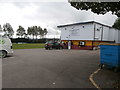
8
No through road signs, Gordon Road, Blackwood
Through traffic needs to turn right here, into Albany Road.
Image: © Jaggery
Taken: 1 May 2013
0.20 miles
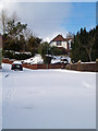
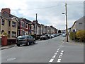
9
Albany Road houses, Blackwood
Houses at the southern end of Albany Road, viewed from the corner of Gordon Road.
Image: © Jaggery
Taken: 1 May 2013
0.22 miles
10
South along Montclaire Avenue, Blackwood
From Gordon Road, Montclaire Avenue leads to the B4254 and Pontllanfraith.
Image: © Jaggery
Taken: 17 May 2018
0.23 miles