IMAGES TAKEN NEAR TO
Greenwood Road, BLACKWOOD, NP12 1EZ
Introduction
This page details the photographs taken nearby to Greenwood Road, NP12 1EZ by members of the Geograph project.
The Geograph project started in 2005 with the aim of publishing, organising and preserving representative images for every square kilometre of Great Britain, Ireland and the Isle of Man.

There are currently over 7.5m images from over14,400 individuals and you can help contribute to the project by visiting https://www.geograph.org.uk
Image Map
Images are licensed for reuse under creativecommons.org/licenses/by-sa/2.0
Notes
- Clicking on the map will re-center to the selected point.
- The higher the marker number, the further away the image location is from the centre of the postcode.
Image Listing (21 Images Found)
Images are licensed for reuse under creativecommons.org/licenses/by-sa/2.0
Image
Details
Distance
1
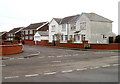
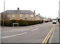
Beaumaris Way, Cefn Fforest, Blackwood
Beaumaris Way houses viewed across Greenwood Road.
Image: © Jaggery
Taken: 17 Jan 2011
0.05 miles
2
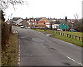
Northern edge of Cefn Fforest, Blackwood
The view along Heol y Cefn on the approach to the boundary of Cefn Fforest, a district in the north of Blackwood. Ahead, Heol y Cefn is renamed Bedwellty Road.
Image: © Jaggery
Taken: 17 Jan 2011
0.06 miles
3
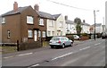
Greenwood Road houses, Cefn Fforest, Blackwood
Viewed from near the corner of Bedwellty Road.
Image: © Jaggery
Taken: 17 Jan 2011
0.07 miles
4
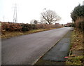
Heol Pit-y-Ceiliogod, Cefn Fforest, Blackwood
Viewed from the corner of Bedwellty Road, looking towards houses at the NW edge of Blackwood.
Image: © Jaggery
Taken: 17 Jan 2011
0.08 miles
5
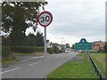
Entering Cefn Fforest
Cefn Fforest is situated on the ridge between the Sirhowy and Rhymney valleys. Approaching from Bedwellty the scenery changes abruptly from farmland to housing estates.
Image: © Robin Drayton
Taken: 27 Sep 2007
0.09 miles
6
Corner of Addison Street and Greenwood Road, Cefn Fforest, Blackwood
Viewed across Greenwood Road from near the corner of Beaumaris Way.
Image: © Jaggery
Taken: 17 Jan 2011
0.11 miles
7
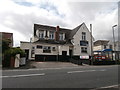
Twyn y Ffald Constitutional Club, Cefn Fforest
Image: © John Lord
Taken: 23 Aug 2017
0.11 miles
8
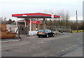
Former Park service station & general store, Cefn Fforest, Blackwood
Fenced-off empty premises located on the west side of Bedwellty Road, almost opposite the turning for Greenwood Road.
Image: © Jaggery
Taken: 17 Jan 2011
0.12 miles
9
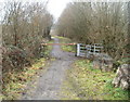
Track barrier, Cefn Fforest, Blackwood
Several tracks lead into a wood named Coed Ty'n-y-pwll. This one branches off from the path to a sports ground. http://www.geograph.org.uk/photo/2235900
A horizontal metal barrier prevents vehicular access. Walkers use the gate on the right.
Image: © Jaggery
Taken: 17 Jan 2011
0.12 miles
10
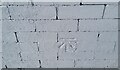
Ordnance Survey Cut Mark
This OS cut mark can be found on Constitutional Club, Bedwellty Road. It marks a point 230.578m above mean sea level.
Image: © Adrian Dust
Taken: 5 Feb 2021
0.12 miles