IMAGES TAKEN NEAR TO
Fairfield Close, Gordon Road, BLACKWOOD, NP12 1EJ
Introduction
This page details the photographs taken nearby to Fairfield Close, Gordon Road, NP12 1EJ by members of the Geograph project.
The Geograph project started in 2005 with the aim of publishing, organising and preserving representative images for every square kilometre of Great Britain, Ireland and the Isle of Man.

There are currently over 7.5m images from over14,400 individuals and you can help contribute to the project by visiting https://www.geograph.org.uk
Image Map
Images are licensed for reuse under creativecommons.org/licenses/by-sa/2.0
Notes
- Clicking on the map will re-center to the selected point.
- The higher the marker number, the further away the image location is from the centre of the postcode.
Image Listing (236 Images Found)
Images are licensed for reuse under creativecommons.org/licenses/by-sa/2.0
Image
Details
Distance
1
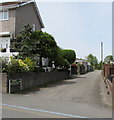
Mayhill Bungalows this way, Blackwood
The white arrow on the sign on the corner of Gordon Road points along the side road to Mayhill Bungalows.
Image: © Jaggery
Taken: 17 May 2018
0.01 miles
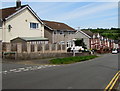
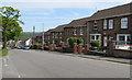
2
Fairfield Close, Blackwood
Short cul-de-sac on the north side of Gordon Road.
Image: © Jaggery
Taken: 17 May 2018
0.02 miles
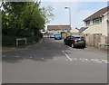
3
Gordon Road below Fairfield Close, Blackwood
Fairfield Close https://www.geograph.org.uk/photo/5777243 is on the left.
Image: © Jaggery
Taken: 17 May 2018
0.03 miles
4
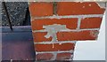
Ordnance Survey Cut Mark
This damaged OS cut mark can be found on No29 Gordon Road. It marks a point 190.820m above mean sea level.
Image: © Adrian Dust
Taken: 22 Jun 2019
0.04 miles
5
Gordon Road houses, Blackwood
The trees are near the corner of Fairfield Close.
Image: © Jaggery
Taken: 17 May 2018
0.04 miles
6
Corner of Gordon Road and Garfield Street, Blackwood
Viewed across Gordon Road.
Image: © Jaggery
Taken: 1 May 2013
0.04 miles
7
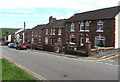
Gordon Road houses, Blackwood
Gordon Road descends towards High Street. The corner of Garfield Street https://www.geograph.org.uk/photo/5777223 is on the right.
Image: © Jaggery
Taken: 17 May 2018
0.04 miles
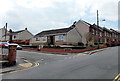
8
BT telephone exchange, Coronation Road, Blackwood
This is the Coronation Road side of the telephone exchange on the corner of Gordon Road.
Image: © Jaggery
Taken: 1 May 2013
0.04 miles
9
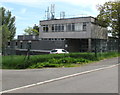
North side of Blackwood Exchange
The Coronation Road side of the BT exchange on the corner of Gordon Road.
The Openreach identifier code for Blackwood Exchange is SWBIG.
Fibre is available to customers connected to this exchange. Most customers can
upgrade from ADSL to fibre internet, including BT Infinity and John Lewis Fibre Broadband.
Image: © Jaggery
Taken: 17 May 2018
0.04 miles
10
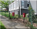
Queen Elizabeth II postbox and a red Royal Mail drop box, Gordon Road, Blackwood
Image: © Jaggery
Taken: 17 May 2018
0.04 miles