IMAGES TAKEN NEAR TO
Libanus Road, BLACKWOOD, NP12 1EH
Introduction
This page details the photographs taken nearby to Libanus Road, NP12 1EH by members of the Geograph project.
The Geograph project started in 2005 with the aim of publishing, organising and preserving representative images for every square kilometre of Great Britain, Ireland and the Isle of Man.

There are currently over 7.5m images from over14,400 individuals and you can help contribute to the project by visiting https://www.geograph.org.uk
Image Map
Images are licensed for reuse under creativecommons.org/licenses/by-sa/2.0
Notes
- Clicking on the map will re-center to the selected point.
- The higher the marker number, the further away the image location is from the centre of the postcode.
Image Listing (94 Images Found)
Images are licensed for reuse under creativecommons.org/licenses/by-sa/2.0
Image
Details
Distance
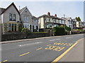
1
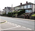
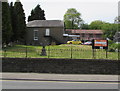
Houses near the southern end of High Street, Blackwood
On the west side of the B4251 High Street on the approach to the B4254 crossroads.
Image: © Jaggery
Taken: 17 May 2018
0.03 miles
2
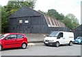
Corrugated metal warehouse, Libanus Road, Blackwood
The notice on the building states that it is private property and that no parking of vehicles is allowed on the forecourt.
Image: © Jaggery
Taken: 24 May 2011
0.03 miles
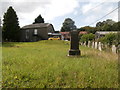
3
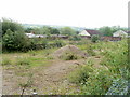
Waste ground, Libanus Road, Blackwood
On the east side of the road, almost opposite a warehouse. http://www.geograph.org.uk/photo/2425787
Image: © Jaggery
Taken: 24 May 2011
0.03 miles
4
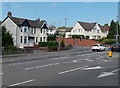
Houses at the Libanus Road junction, Blackwood
Viewed across Blackwood Road which becomes High Street, Blackwood beyond the traffic lights.
The left turn is into Libanus Road.
Image: © Jaggery
Taken: 22 Aug 2013
0.04 miles
5
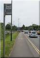
Twelve routes shown on a High Street bus stop sign, Blackwood
The Blackwood Gate Retail Park bus stop sign shows that buses on twelve routes stop here in May 2018. Bus stops signs are not always up-to-date. In this case, the bus timetable inside the nearby bus shelter shows that buses on thirteen routes stop here. The location is about 600 metres south of Blackwood bus station,
at a point before any southbound routes diverge.
Image: © Jaggery
Taken: 17 May 2018
0.04 miles
6
Libanus Primary School, Blackwood
Located on the west side of Libanus Road.
Image: © Jaggery
Taken: 24 May 2011
0.05 miles
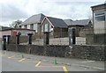
7
Libanus Christian Centre, formerly Libanus Baptist Chapel, Blackwood
Image: © John Lord
Taken: 24 Aug 2017
0.06 miles
8
West side of High Street, Blackwood
Houses viewed from Blackwood Gate Retail Park bus stop near the southern end of High Street.
Image: © Jaggery
Taken: 17 May 2018
0.06 miles
9
Libanus Christian Centre, Blackwood
Located between High Street and Libanus Road. The building was originally
Libanus Baptist Chapel which was built in 1829, modified in 1903.
Image: © Jaggery
Taken: 17 May 2018
0.06 miles
10
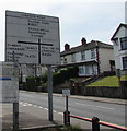
Directions sign near the southern end of High Street, Blackwood
Alongside the B4251 High Street on the approach to the crossroads at the B4251/B4254 intersection.
Image: © Jaggery
Taken: 17 May 2018
0.06 miles