1
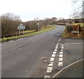
Heol Pit-y-Ceiliogod, Cefn Fforest, Blackwood
Viewed from the corner of Bedwellty Road, looking towards houses at the NW edge of Blackwood.
Image: © Jaggery
Taken: 17 Jan 2011
0.02 miles
2
Entering Cefn Fforest
Cefn Fforest is situated on the ridge between the Sirhowy and Rhymney valleys. Approaching from Bedwellty the scenery changes abruptly from farmland to housing estates.
Image: © Robin Drayton
Taken: 27 Sep 2007
0.09 miles
3
Northern edge of Cefn Fforest, Blackwood
The view along Heol y Cefn on the approach to the boundary of Cefn Fforest, a district in the north of Blackwood. Ahead, Heol y Cefn is renamed Bedwellty Road.
Image: © Jaggery
Taken: 17 Jan 2011
0.09 miles
4
Beaumaris Way, Cefn Fforest, Blackwood
Beaumaris Way houses viewed across Greenwood Road.
Image: © Jaggery
Taken: 17 Jan 2011
0.11 miles
5
Greenwood Road houses, Cefn Fforest, Blackwood
Viewed from near the corner of Bedwellty Road.
Image: © Jaggery
Taken: 17 Jan 2011
0.14 miles
6
Heol Y Cefn leaves Cefn Fforest, Blackwood
Bedwellty Road is renamed Heol Y Cefn on passing the turning on the right for Heol Pit-y-Ceiliogod. http://www.geograph.org.uk/photo/2235834 The speed limit increases from 30mph to the national speed limit.
Image: © Jaggery
Taken: 17 Jan 2011
0.14 miles
7
Former Park service station & general store, Cefn Fforest, Blackwood
Fenced-off empty premises located on the west side of Bedwellty Road, almost opposite the turning for Greenwood Road.
Image: © Jaggery
Taken: 17 Jan 2011
0.15 miles
8
Track barrier, Cefn Fforest, Blackwood
Several tracks lead into a wood named Coed Ty'n-y-pwll. This one branches off from the path to a sports ground. http://www.geograph.org.uk/photo/2235900
A horizontal metal barrier prevents vehicular access. Walkers use the gate on the right.
Image: © Jaggery
Taken: 17 Jan 2011
0.15 miles
9
Corner of Addison Street and Greenwood Road, Cefn Fforest, Blackwood
Viewed across Greenwood Road from near the corner of Beaumaris Way.
Image: © Jaggery
Taken: 17 Jan 2011
0.17 miles
10
Twyn y Ffald Constitutional Club, Cefn Fforest
Image: © John Lord
Taken: 23 Aug 2017
0.18 miles


