IMAGES TAKEN NEAR TO
Willow Drive, BLACKWOOD, NP12 0UP
Introduction
This page details the photographs taken nearby to Willow Drive, NP12 0UP by members of the Geograph project.
The Geograph project started in 2005 with the aim of publishing, organising and preserving representative images for every square kilometre of Great Britain, Ireland and the Isle of Man.

There are currently over 7.5m images from over14,400 individuals and you can help contribute to the project by visiting https://www.geograph.org.uk
Image Map
Images are licensed for reuse under creativecommons.org/licenses/by-sa/2.0
Notes
- Clicking on the map will re-center to the selected point.
- The higher the marker number, the further away the image location is from the centre of the postcode.
Image Listing (117 Images Found)
Images are licensed for reuse under creativecommons.org/licenses/by-sa/2.0
Image
Details
Distance
1
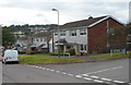
Corner of Vale View Road and Yew Grove, Pontllanfraith
Houses in the Woodfieldside district of Pontllanfraith.
Image: © Jaggery
Taken: 8 Aug 2012
0.07 miles
2
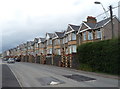
Woodfield Terrace, Pontllanfraith
A long row of houses on the east side of Woodfield Terrace in the Woodfieldside district of Pontllanfraith.
Image: © Jaggery
Taken: 8 Aug 2012
0.11 miles
3
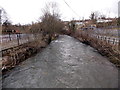
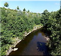
Sirhowy flows away from Bridge Street, Blackwood
River view from here. http://www.geograph.org.uk/photo/4026716
Image: © Jaggery
Taken: 18 Feb 2014
0.11 miles
4
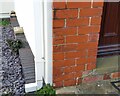
Ordnance Survey Cut Mark
This OS cut mark can be found on Melrose House, Woodfield Terrace. It marks a point 160.916m above mean sea level.
Image: © Adrian Dust
Taken: 9 Feb 2021
0.11 miles
5
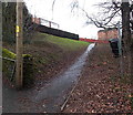
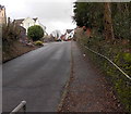
Path up from Park Terrace, Blackwood
Ascending towards Elm Court and Willow Drive.
Image: © Jaggery
Taken: 18 Feb 2014
0.11 miles
6
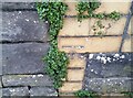
Ordnance Survey Cut Mark
This OS cut mark can be found on the wall between Nos 11 & 12 Church View. It marks a point 153.814m above mean sea level.
Image: © Adrian Dust
Taken: 9 Feb 2021
0.11 miles
7
Woodfieldside boundary sign, Pontllanfraith
The green boundary sign is on the corner of Park Terrace and Woodfield Terrace.
Woodfieldside is a district of Pontllanfraith.
Image: © Jaggery
Taken: 8 Aug 2012
0.12 miles
8
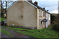
Terraced houses, west of Pleasant Close
I have not been able to find the name of this short row which is reached by a narrow unnamed road off Penmaen Road. The track in the left foreground leads to a garage; other garages are to the right out of the picture.
Image: © M J Roscoe
Taken: 2 Jan 2016
0.13 miles
9
Sirhowy cliff, Blackwood
The Sirhowy flows towards the camera on the bridge carrying Sirhowy Enterprise Way over the river.
On the top of the cliff on the left is the edge of a retail park.
Image: © Jaggery
Taken: 22 Aug 2013
0.13 miles
10
Park Terrace, Woodfieldside, Blackwood
Ascending from the Sirhowy River valley.
Image: © Jaggery
Taken: 18 Feb 2014
0.13 miles