IMAGES TAKEN NEAR TO
William Street, BLACKWOOD, NP12 0SL
Introduction
This page details the photographs taken nearby to William Street, NP12 0SL by members of the Geograph project.
The Geograph project started in 2005 with the aim of publishing, organising and preserving representative images for every square kilometre of Great Britain, Ireland and the Isle of Man.

There are currently over 7.5m images from over14,400 individuals and you can help contribute to the project by visiting https://www.geograph.org.uk
Image Map
Images are licensed for reuse under creativecommons.org/licenses/by-sa/2.0
Notes
- Clicking on the map will re-center to the selected point.
- The higher the marker number, the further away the image location is from the centre of the postcode.
Image Listing (50 Images Found)
Images are licensed for reuse under creativecommons.org/licenses/by-sa/2.0
Image
Details
Distance
1
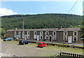
William Street, Hollybush
A 40 metre long row of houses on the west bank of a river, the Sirhowy. Viewed from Railway Terrace.
Image: © Jaggery
Taken: 1 Aug 2013
0.01 miles
2
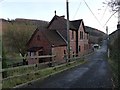
Former station building, Hollybush
The station opened in 1891 and closed 1960 with the line finally being closed in 1969.
Image: © Robin Drayton
Taken: 16 Nov 2010
0.02 miles
3
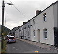
Northern end of Railway Terrace, Hollybush
Looking south from this http://www.geograph.org.uk/photo/3580350 turning area.
Image: © Jaggery
Taken: 1 Aug 2013
0.02 miles
4
Station House, Hollybush
Viewed across Railway Terrace. This was the location of the village railway station (named Holly Bush).
Passenger services ended in 1960.
Image: © Jaggery
Taken: 1 Aug 2013
0.02 miles
5
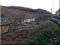
The Sirhowy Valley at Hollybush
The terrace of houses in the centre is William Street.
The River Sirhowy flows behind these houses.
The route of the former railway is visible from in front of the modern building on the left with the former station building http://www.geograph.org.uk/photo/2168291 in the distance.
Image: © Robin Drayton
Taken: 16 Nov 2010
0.03 miles
6
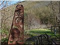
Entrance to Upper Sirhowy Valley Community Woodlands, Hollybush
The gateways to the woodlands were designed by Rubin Eynon using Welsh oak, pennant sandstone and iron.
The steam locomotive is a reminder that a busy railway line from Tredegar to Newport once ran through the valley.
The woodlands were opened by HRH The Princess Royal in 2008.
Image: © Robin Drayton
Taken: 1 Apr 2014
0.03 miles
7
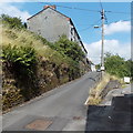
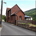
Railway Cottages, Railway Terrace, Hollybush
Railway Cottages are set above the roadway on the west side of Railway Terrace.
Image: © Jaggery
Taken: 1 Aug 2013
0.03 miles
8
The site of Hollybush station
The cars on the left are parked on the former platform.
For earlier pictures of the station see http://www.tredegar.co.uk/gallery/gallery.asp?action=viewimage&categoryid=48&text=&imageid=6624&box=&shownew= .
Image: © Robin Drayton
Taken: 16 Nov 2010
0.03 miles
9
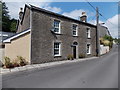
Yr Hen Llwyncelyn, Hollybush
Viewed across Railway Terrace. Some online references show a pub, the Hollybush Inn, in Railway Terrace. There is no inn here now (August 2013). Perhaps this large building used to be the inn.
The translation of Yr Hen Llwyncelyn is The Old Hollybush...
Image: © Jaggery
Taken: 1 Aug 2013
0.04 miles
10
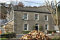
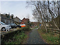
House, Railway Terrace, Hollybush
House close to the former Hollybush railway station; the pile of logs is across the road on the former station platform.
Image: © M J Roscoe
Taken: 10 Nov 2016
0.04 miles