IMAGES TAKEN NEAR TO
Manmoel, BLACKWOOD, NP12 0RN
Introduction
This page details the photographs taken nearby to NP12 0RN by members of the Geograph project.
The Geograph project started in 2005 with the aim of publishing, organising and preserving representative images for every square kilometre of Great Britain, Ireland and the Isle of Man.

There are currently over 7.5m images from over14,400 individuals and you can help contribute to the project by visiting https://www.geograph.org.uk
Image Map
Images are licensed for reuse under creativecommons.org/licenses/by-sa/2.0
Notes
- Clicking on the map will re-center to the selected point.
- The higher the marker number, the further away the image location is from the centre of the postcode.
Image Listing (33 Images Found)
Images are licensed for reuse under creativecommons.org/licenses/by-sa/2.0
Image
Details
Distance
1

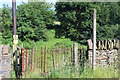
Field footpath to Manmoel
Public footpath, part of the Sirhowy Valley Walk, through a meadow to a gate on the road in Manmoel village. Viewed from the gateway in a new fence not shown on the current OS map
Image: © M J Roscoe
Taken: 1 Jul 2017
0.02 miles
2
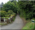
Lane to Gelligoediog Riding Stables, Manmoel
The lane heads south away from the central part of the small village.
The riding stables are about 600 metres ahead, in Gelligoediog Farm.
Image: © Jaggery
Taken: 13 Jul 2014
0.02 miles
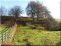
4
Field footpath to Tir y Pentre Farm
This public footpath goes down into a dip (out of sight) and then veers to the right up the hillside.
Image: © M J Roscoe
Taken: 1 Jul 2017
0.04 miles
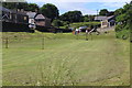
5
Manmoel sports field
On the south side of the children's play area. http://www.geograph.org.uk/photo/4100700 I wondered what sports are played here.
The goalposts and the (unlined) pitch are too small for it to be a standard football pitch. There are four benches along an edge of the pitch.
Image: © Jaggery
Taken: 13 Jul 2014
0.05 miles
6
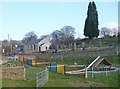
Play area, Manmoel
A children's play area adjacent to Paran Calvinistic Methodist Chapel.
Image: © Robin Drayton
Taken: 19 Dec 2007
0.07 miles
7
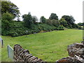
Playing field at Manmoel
Small village playing field with play area beyond and beyond Paran Chapel to the right.
Image: © M J Roscoe
Taken: 1 Jul 2017
0.08 miles
8

Manmoel Inn, Manmoel
Located in the middle of a small upland village in Caerphilly County Borough.
On the right, a red arrow points towards a public footpath. http://www.geograph.org.uk/photo/4100732
Image: © Jaggery
Taken: 13 Jul 2014
0.08 miles
9
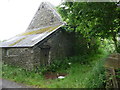
Immaculate old stone barn near Manmoel
This old stone barn has always been well looked after as it survives in better condition than many similar barns.
Image: © Jeremy Bolwell
Taken: 18 Jul 2011
0.08 miles
10
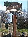
Manmoel village sign
Manmoel village sign adjacent to and showing Paran Calvinistic Methodist Chapel. The sign indicates that Manmoel was established in the 11th century.
Image: © Robin Drayton
Taken: 19 Dec 2007
0.09 miles