IMAGES TAKEN NEAR TO
Manmoel, BLACKWOOD, NP12 0RL
Introduction
This page details the photographs taken nearby to NP12 0RL by members of the Geograph project.
The Geograph project started in 2005 with the aim of publishing, organising and preserving representative images for every square kilometre of Great Britain, Ireland and the Isle of Man.

There are currently over 7.5m images from over14,400 individuals and you can help contribute to the project by visiting https://www.geograph.org.uk
Image Map
Images are licensed for reuse under creativecommons.org/licenses/by-sa/2.0
Notes
- Clicking on the map will re-center to the selected point.
- The higher the marker number, the further away the image location is from the centre of the postcode.
Image Listing (35 Images Found)
Images are licensed for reuse under creativecommons.org/licenses/by-sa/2.0
Image
Details
Distance
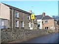
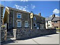
1

Manmoel Inn, Manmoel
Located in the middle of a small upland village in Caerphilly County Borough.
On the right, a red arrow points towards a public footpath. http://www.geograph.org.uk/photo/4100732
Image: © Jaggery
Taken: 13 Jul 2014
0.01 miles
2
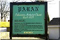
Historical sign for Paran Church Manmoel
This shows the sign at Paran Church Manmoel which outlines the founding history of the site.
Image: © Peter Hutchings
Taken: 21 Jan 2006
0.02 miles
3
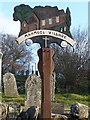
Manmoel village sign
Manmoel village sign adjacent to and showing Paran Calvinistic Methodist Chapel. The sign indicates that Manmoel was established in the 11th century.
Image: © Robin Drayton
Taken: 19 Dec 2007
0.02 miles
4
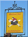
Manmoel Inn Sign
Rhymney Brewery was established in 1839 and closed in 1978. The famous Hobby Horse trademark of the little man on the barrel, designed by a keen sportsman, became well known familiar sight throughout Wales and especially the Valleys.
Image: © Robin Drayton
Taken: 19 Dec 2007
0.02 miles
5
Manmoel Inn
Village inn which is now closed and has been converted for residential use.
Image: © Alan Hughes
Taken: 15 Jul 2021
0.03 miles
6
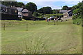
Playing field at Manmoel
Small village playing field with play area beyond and beyond Paran Chapel to the right.
Image: © M J Roscoe
Taken: 1 Jul 2017
0.03 miles
7

Postbox and kissing gate in Manmoel
The gate is at the entrance to this http://www.geograph.org.uk/photo/4100700 children's play area.
Image: © Jaggery
Taken: 13 Jul 2014
0.03 miles
8
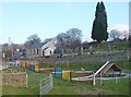
Play area, Manmoel
A children's play area adjacent to Paran Calvinistic Methodist Chapel.
Image: © Robin Drayton
Taken: 19 Dec 2007
0.03 miles
9
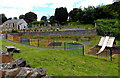
Children's play area in Manmoel
Located between the road through the middle of the village and Paran church and churchyard.
Image: © Jaggery
Taken: 13 Jul 2014
0.03 miles