1
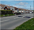
James Street, Markham
The houses are opposite playing fields and a school.
Image: © Jaggery
Taken: 1 Jun 2013
0.02 miles
2
Blackwood Automotive Ltd, Markham
Located near James Street alongside the road north from Bedwellty.
The business undertakes car accident repairs and resprays, and mechanical work.
Image: © Jaggery
Taken: 1 Jun 2013
0.10 miles
3
Markham Medical Centre
Located in a pyramid-like building inside a fenced compound at the SW edge of James Street.
Image: © Jaggery
Taken: 1 Jun 2013
0.10 miles
4
Markham Primary School
Located on the south side of Pantycefn Road. Formerly, there were two separate schools here, an infants school and a junior school, each with its own staff and head teacher. In the 1970s, Markham Primary School was established with nursery, infants and junior departments.
Image: © Jaggery
Taken: 1 Jun 2013
0.12 miles
5
Pantycefn Road bungalows, Markham
Semi-detached bungalows on the north side of the B4511 Pantycefn Road.
Image: © Jaggery
Taken: 1 Jun 2013
0.13 miles
6
Markham War Memorial
Located on a triangular green on the south side of the B4511 Pantycefn Road.
Image: © Jaggery
Taken: 1 Jun 2013
0.13 miles
7
War Memorial, Markham (1)
Situated at a road junction on the western outskirts of Markham.
For a closer view see http://www.geograph.org.uk/photo/3912938 .
Image: © Robin Drayton
Taken: 1 Apr 2014
0.13 miles
8
War Memorial, Markham (2)
The three plaques name local residents who died in World War II, the Korean War and the Northern Ireland Troubles.
Image: © Robin Drayton
Taken: 1 Apr 2014
0.13 miles
9
Round and round we go, Markham
The mini-roundabout is at the junction of the B4511 Pantycefn Road and Heol-y-Bedw-Hirion.
Image: © Jaggery
Taken: 1 Jun 2013
0.14 miles
10
One-way system in Markham
A one-way system operates around this grass triangle.
Markham War Memorial http://www.geograph.org.uk/photo/3491246 is at the right edge of the triangle.
Image: © Jaggery
Taken: 1 Jun 2013
0.15 miles


