IMAGES TAKEN NEAR TO
Bryn Road, BLACKWOOD, NP12 0QB
Introduction
This page details the photographs taken nearby to Bryn Road, NP12 0QB by members of the Geograph project.
The Geograph project started in 2005 with the aim of publishing, organising and preserving representative images for every square kilometre of Great Britain, Ireland and the Isle of Man.

There are currently over 7.5m images from over14,400 individuals and you can help contribute to the project by visiting https://www.geograph.org.uk
Image Map
Images are licensed for reuse under creativecommons.org/licenses/by-sa/2.0
Notes
- Clicking on the map will re-center to the selected point.
- The higher the marker number, the further away the image location is from the centre of the postcode.
Image Listing (45 Images Found)
Images are licensed for reuse under creativecommons.org/licenses/by-sa/2.0
Image
Details
Distance
1
Mountain View, Markham
Mountain View is a residential cul-de-sac on the north side of Pantycefn Road.
Image: © Jaggery
Taken: 1 Jun 2013
0.03 miles
2
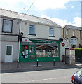
Markham Post Office
Located at the NW end of a short row of shops in Abernant Road Markham.
The postbox is in the wall on the right behind the phonebox.
Image: © Jaggery
Taken: 1 Jun 2013
0.05 miles
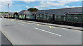
3
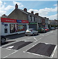
Shops and speed bumps, Markham
This short row of shops is in Abernant Road. Markham Post Office http://www.geograph.org.uk/photo/3488733 is at the far end.
There have been various changes since this http://www.geograph.org.uk/photo/502528 view taken in July 2007. Among the most noticeable are : the OneStop nameboard is different, a cash machine has been installed in the wall
and the 6am-11pm opening hours in 2007 are now (June 1st 2013) 6am-10pm.
Image: © Jaggery
Taken: 1 Jun 2013
0.05 miles
4
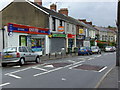
Markham
A row of shops and the Post Office in Abernant road.
Image: © Sally Lloyd
Taken: 22 Jul 2007
0.06 miles
6
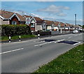
Pantycefn Road bungalows, Markham
Semi-detached bungalows on the north side of the B4511 Pantycefn Road.
Image: © Jaggery
Taken: 1 Jun 2013
0.07 miles
7
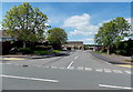
Markham Primary School
Located on the south side of Pantycefn Road. Formerly, there were two separate schools here, an infants school and a junior school, each with its own staff and head teacher. In the 1970s, Markham Primary School was established with nursery, infants and junior departments.
Image: © Jaggery
Taken: 1 Jun 2013
0.08 miles
8
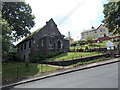
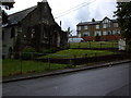
Corner view of the Congregational Chapel, Markham
Viewed from near the corner of Abernant Road. The chapel was built in 1922.
Image: © Jaggery
Taken: 1 Aug 2013
0.08 miles
9
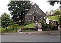
Front view of the Congregational Chapel, Markham
The chapel, built in 1922, is located between Abernant Road and Pen-y-werlod Road.
Image: © Jaggery
Taken: 1 Aug 2013
0.08 miles
10
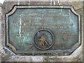
Plaque on the miners' memorial, Markham
http://www.geograph.org.uk/photo/2139575
Image: © Robin Drayton
Taken: 8 Oct 2010
0.08 miles