IMAGES TAKEN NEAR TO
Penrhiw Terrace, BLACKWOOD, NP12 0JH
Introduction
This page details the photographs taken nearby to Penrhiw Terrace, NP12 0JH by members of the Geograph project.
The Geograph project started in 2005 with the aim of publishing, organising and preserving representative images for every square kilometre of Great Britain, Ireland and the Isle of Man.

There are currently over 7.5m images from over14,400 individuals and you can help contribute to the project by visiting https://www.geograph.org.uk
Image Map
Images are licensed for reuse under creativecommons.org/licenses/by-sa/2.0
Notes
- Clicking on the map will re-center to the selected point.
- The higher the marker number, the further away the image location is from the centre of the postcode.
Image Listing (61 Images Found)
Images are licensed for reuse under creativecommons.org/licenses/by-sa/2.0
Image
Details
Distance
1
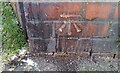
Ordnance Survey Cut Mark
This OS cut mark can be found on the wall of the Old Hospital. Now No13 Penrhin. It marks a point 232.297m above mean sea level.
Image: © Adrian Dust
Taken: 9 Feb 2021
0.05 miles
2
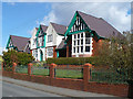
Oakdale Community Hospital
Opened in 1915.
Image: © Robin Drayton
Taken: 5 Apr 2008
0.07 miles
3
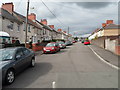
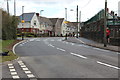
Asheville, Oakdale
The residential street Asheville climbs away from Central Avenue.
Image: © Jaggery
Taken: 8 Aug 2012
0.08 miles
4
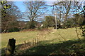
Field by footpath on hillside
Field below the former B4251 road, Oakdale. The straggly line of dead plants leads to the gateway to the next field, with houses of Rising Sun Close beyond. Viewed from gate in Image
Image: © M J Roscoe
Taken: 6 Mar 2021
0.10 miles
5
Belisha beacons, Syr Dafydd Avenue, Oakdale
New zebra crossing and realigned kerb next to Ysgol Gymraeg Cwm Derwen (boundary wall on right), completed in early April 2015. This is part of a Safe Routes Project, Image
Image: © M J Roscoe
Taken: 8 Apr 2016
0.10 miles
6

Ordnance Survey Cut Mark
This OS cut mark can be found on the wall SE side of Rhiw Syr Dafyed Hill. It marks a point 199.376m above mean sea level.
Image: © Adrian Dust
Taken: 9 Feb 2021
0.10 miles
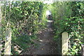
7
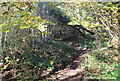
Footpath off Rhiw Syr Dafydd, Oakdale
Woodland path along hillside leading up to Bronwydd.
Image: © M J Roscoe
Taken: 21 Nov 2015
0.11 miles
8
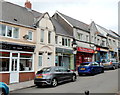
Oakdale shops in The Square
Shops on the west side of The Square, the main shopping area in the village.
Image: © Jaggery
Taken: 8 Aug 2012
0.12 miles
9
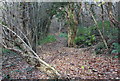
Woodland, bottom of Rhiw Syr Dafydd Hill, Oakdale
Informal path in edge of woodland on a sunny autumn afternoon.
Image: © M J Roscoe
Taken: 1 Nov 2015
0.13 miles
10
Public footpath up towards West View Crescent
Stone-paved path viewed from below gate Image, now off its hinges.
Image: © M J Roscoe
Taken: 25 Apr 2020
0.13 miles