IMAGES TAKEN NEAR TO
Courtabella, BLACKWOOD, NP12 0HT
Introduction
This page details the photographs taken nearby to Courtabella, NP12 0HT by members of the Geograph project.
The Geograph project started in 2005 with the aim of publishing, organising and preserving representative images for every square kilometre of Great Britain, Ireland and the Isle of Man.

There are currently over 7.5m images from over14,400 individuals and you can help contribute to the project by visiting https://www.geograph.org.uk
Image Map
Images are licensed for reuse under creativecommons.org/licenses/by-sa/2.0
Notes
- Clicking on the map will re-center to the selected point.
- The higher the marker number, the further away the image location is from the centre of the postcode.
Image Listing (48 Images Found)
Images are licensed for reuse under creativecommons.org/licenses/by-sa/2.0
Image
Details
Distance
1
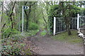
Sirhowy Valley Walk from former Cwrt-y-bella Crossing
The path here runs north, parallel with the former railway. The footpath sign points to a path at right angles to the Walk.
Image: © M J Roscoe
Taken: 20 Apr 2017
0.04 miles
2

Site of altar of demolished church, Cwrt-y-Bella
The hedge encloses almost completely a rectangle which a small plaque on the ground states was the position of the altar of the demolished Church of St Philip & St James.
Image: © M J Roscoe
Taken: 29 May 2020
0.07 miles
3
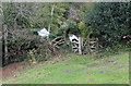
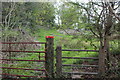
'Kissing gate', Sirhowy Valley Walk, south of Argoed
Two wooden steps lead up to the gate at a modified former level crossing.
Image: © M J Roscoe
Taken: 15 Oct 2015
0.07 miles
4
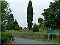
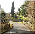
The road past Cwrt-y-Bella cemetery
This hillside cemetery is maintained by St David's Church, Penmaen.
Image: © Robin Drayton
Taken: 30 Jul 2010
0.07 miles
5
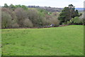
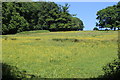
Field above Cwrt-y-bella Cemetery, Grwhay
The cemetery is the other side of the wall (centre); the yew tree (right) is on the site of the demolished church of St Philip & St James.
Image: © M J Roscoe
Taken: 20 Apr 2017
0.07 miles
6
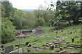
Cwrt-y-Bella Cemetery
Partly overgrown graveyard in grounds of demolished church which stood just to the right of the yew tree (right). Trees have been felled and/or fallen near an entrance.
Image: © M J Roscoe
Taken: 13 May 2020
0.08 miles
7
Stile next to gate on track, Grwhay
The public footpath on the other side of the stile leads initially to former colliery workings.
Image: © M J Roscoe
Taken: 20 Apr 2017
0.08 miles
8

Entrance to Cwrt-y-Bella cemetery
Cwrt-y-Bella cemetery is now maintained by St David's Church, Penmaen, Oakdale.
Their blue notice board is on the right. Cwrt-y-Bella church was demolished in the
early 1970s.
Image: © Jaggery
Taken: 1 Mar 2010
0.09 miles
9
Eastern edge of Cwm-Corrwg
The lane from the B4251 approaches the eastern edge of Cwm-Corrwg, and
Cwrt-y-Bella cemetery.
Image: © Jaggery
Taken: 1 Mar 2010
0.09 miles
10
Buttercup-rich meadow by footpath
Meadow next to Sirhowy Valley Walk near Cwrt-y-Bella.
Image: © M J Roscoe
Taken: 29 May 2020
0.09 miles