IMAGES TAKEN NEAR TO
Bronwydd, BLACKWOOD, NP12 0GX
Introduction
This page details the photographs taken nearby to Bronwydd, NP12 0GX by members of the Geograph project.
The Geograph project started in 2005 with the aim of publishing, organising and preserving representative images for every square kilometre of Great Britain, Ireland and the Isle of Man.

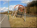
There are currently over 7.5m images from over14,400 individuals and you can help contribute to the project by visiting https://www.geograph.org.uk
Image Map
Images are licensed for reuse under creativecommons.org/licenses/by-sa/2.0
Notes
- Clicking on the map will re-center to the selected point.
- The higher the marker number, the further away the image location is from the centre of the postcode.
Image Listing (71 Images Found)
Images are licensed for reuse under creativecommons.org/licenses/by-sa/2.0
Image
Details
Distance
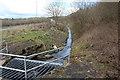
1
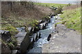
Stepped waterfall alongside B4251, Oakdale
On the east side of the B4251, a stream descends along a series of stone steps.
It drops 18 metres, from 212 metres above mean sea level, to 194 metres above MSL.
At the top of the waterfall is an area of flat moorland. http://www.geograph.org.uk/photo/1734031
Image: © Jaggery
Taken: 1 Mar 2010
0.05 miles
2
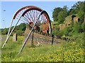
Miners' Memorial, Oakdale
The plaque states:
OAKDALE COLLIERIES 1908 - 1989
OUT OF DARKNESS LET THERE BE LIGHT
In memory of those Oakdale Miners who dedicated their lives for the benefit of their Nation.
Image: © Robin Drayton
Taken: 9 Jun 2006
0.06 miles
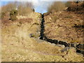
3
Drain next to Yard Coal Rise, Oakdale
Man made stone lined channel running from the bottom of the cascade in Image
Image: © M J Roscoe
Taken: 30 Mar 2016
0.07 miles
4
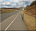
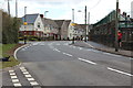
Cyclists to the left, pedestrians to the right, Oakdale
The view along the B4251 adjacent to Foxes Lane. http://www.geograph.org.uk/photo/1733958
The pavement is neatly divided into a cyclists' half and a pedestrian half, though I wonder when this route gets busy. During my walk in the area, I saw only one other pedestrian, and no cyclists.
Image: © Jaggery
Taken: 1 Mar 2010
0.08 miles
5
Oakdale miners' memorial
Located on the east side of the B4251 is the representation of colliery winding wheels. Alongside it is a stone plaque http://www.geograph.org.uk/photo/1733998 dedicating the memorial to the Oakdale miners.
Image: © Jaggery
Taken: 1 Mar 2010
0.08 miles
6
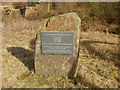
Oakdale miners' memorial stone
Alongside the representation of colliery winding wheels http://www.geograph.org.uk/photo/1733988 beside the B4251 is a stone plaque, with an inscription in Welsh and English. The English text reads
OAKDALE COLLIERIES 1908-1989
OUT OF THE DARKNESS LET THERE BE LIGHT
In memory of those Oakdale Miners who dedicated their lives for the benefit of their Nation.
Image: © Jaggery
Taken: 1 Mar 2010
0.08 miles
7
Belisha beacons, Syr Dafydd Avenue, Oakdale
New zebra crossing and realigned kerb next to Ysgol Gymraeg Cwm Derwen (boundary wall on right), completed in early April 2015. This is part of a Safe Routes Project, Image
Image: © M J Roscoe
Taken: 8 Apr 2016
0.09 miles
8
Cascade above Yard Coal Rise, Oakdale
Man made cascade of stone blocks from the edge of the site of the new Islwyn High School down to the B4251; all built on landscaped colliery waste. Compare with the view in Image
Image: © M J Roscoe
Taken: 30 Mar 2016
0.09 miles
9
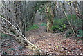
Footpath off Rhiw Syr Dafydd, Oakdale
Woodland path along hillside leading up to Bronwydd.
Image: © M J Roscoe
Taken: 21 Nov 2015
0.13 miles
10
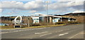
Foxes Lane, Oakdale
Alongside the B4251 is small, detached section of Oakdale Business Park, most of which is about a kilometre further along the road. Businesses located here include confectionery company Bon Bon Buddies (BBB).
Formerly the site of a mine, the Lane was previously named Old Coal Avenue. The change of name occurred in 2008 at the request of Bon Bon Buddies who have expanded their business considerably and have gone from 11 employees to almost 80, hence the relocation to the new premises, which officially opened in 2008.
The new name Foxes Lane has an important historical and local connection. It reflects a unique family association with Oakdale Colliery, in that both father (Jack Fox) and his son David were colliery managers at the same mine. Jack Fox was Oakdale colliery manager for many years during the 1950s and 1960s. His son was colliery manager there in the 1980s, up to the closure of the mine.
Image: © Jaggery
Taken: 1 Mar 2010
0.14 miles