IMAGES TAKEN NEAR TO
Manmoel, BLACKWOOD, NP12 0GD
Introduction
This page details the photographs taken nearby to NP12 0GD by members of the Geograph project.
The Geograph project started in 2005 with the aim of publishing, organising and preserving representative images for every square kilometre of Great Britain, Ireland and the Isle of Man.

There are currently over 7.5m images from over14,400 individuals and you can help contribute to the project by visiting https://www.geograph.org.uk
Image Map
Images are licensed for reuse under creativecommons.org/licenses/by-sa/2.0
Notes
- Clicking on the map will re-center to the selected point.
- The higher the marker number, the further away the image location is from the centre of the postcode.
Image Listing (15 Images Found)
Images are licensed for reuse under creativecommons.org/licenses/by-sa/2.0
Image
Details
Distance
1
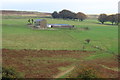
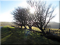
Towards Maes-yr-onn-fach
Looking across the head of a small valley to the farm Image which straddles the grid line.
Image: © M J Roscoe
Taken: 15 Oct 2017
0.02 miles
2
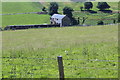
Maes-yr-onn-fach
A house, with solar panels, near the head of a small valley.
Image: © M J Roscoe
Taken: 18 Jun 2017
0.03 miles
3
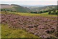
Nant yr Helyg from the Man-moel Road
The Sirhowy Valley Walk gets up above the valley of Nant yr Helyg. This is looking south with Hollybush in the distance.
Image: © Graham Horn
Taken: 17 Aug 2008
0.07 miles
4
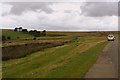
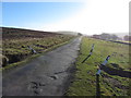
Man-moel Road
The road leads from the village of Manmoel over Cefn Manmoel (although strangely the road name has a hypen and the other two don't). It is part of the Sirhowy Valley Walk, but is also driveable with care (it gets worse). I did wonder whether this was a fellow geographer parked up here but I have not seen any photographic evidence yet.
Image: © Graham Horn
Taken: 17 Aug 2008
0.07 miles
6
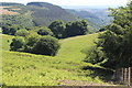
Valley off Sirhowy Valley
Head of an unnamed valley which turns to the right into the Sirhowy Valley. The coniferous woodland on the hillside to the left is part of Coed y Llanerch.
Image: © M J Roscoe
Taken: 18 Jun 2017
0.12 miles
7
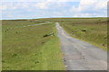
Manmoel Road crossing Manmoel Common
The minor somewhat uneven road, part of the Sirhowy Valley Walk, from Manmoel Village.
Image: © M J Roscoe
Taken: 18 Jun 2017
0.15 miles
8
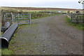
Sirhowy Valley Walk, Cruglwyn
The alternative western route of the Walk near its junction with the main route on Manmoel Road.
Image: © M J Roscoe
Taken: 15 Oct 2017
0.16 miles
10
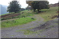
Track, Cruglwyn
Alternative route of the Sirhowy Valley Walk on a track heading downhill
Image: © M J Roscoe
Taken: 15 Oct 2017
0.17 miles