IMAGES TAKEN NEAR TO
Woodfield Park Lane, BLACKWOOD, NP12 0EU
Introduction
This page details the photographs taken nearby to Woodfield Park Lane, NP12 0EU by members of the Geograph project.
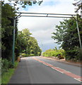
The Geograph project started in 2005 with the aim of publishing, organising and preserving representative images for every square kilometre of Great Britain, Ireland and the Isle of Man.

There are currently over 7.5m images from over14,400 individuals and you can help contribute to the project by visiting https://www.geograph.org.uk
Image Map
Images are licensed for reuse under creativecommons.org/licenses/by-sa/2.0
Notes
- Clicking on the map will re-center to the selected point.
- The higher the marker number, the further away the image location is from the centre of the postcode.
Image Listing (72 Images Found)
Images are licensed for reuse under creativecommons.org/licenses/by-sa/2.0
Image
Details
Distance
1
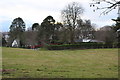
Woodfield Park Funeral Home
Viewed across a meadow from near allotments.
Image: © M J Roscoe
Taken: 1 Jan 2019
0.04 miles
2
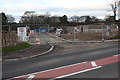
Building site in Woodfield Park
Construction of new housing estate on what was a meadow of significance for wildlife.
Image: © M J Roscoe
Taken: 1 Jan 2019
0.08 miles
3
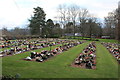
Garden of Remembrance, Woodfield Park
Memorial garden next to the funeral home Image visible in the background.
Image: © M J Roscoe
Taken: 1 Jan 2019
0.08 miles
4
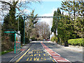
Bus stop and bat crossing, Oakdale Terrace, Penmaen
With the construction of the nearby Sirhowy Enterprise Way, several bat crossings were constructed in the area to mitigate for the loss of an old railway bridge.
Image: © Robin Drayton
Taken: 5 Apr 2008
0.09 miles
5
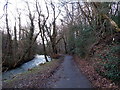
Public footpath through St David's Wood, Blackwood
Along a bank of the Sirhowy River.
Image: © Jaggery
Taken: 18 Feb 2014
0.11 miles
6
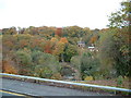
View across valley towards Woodfieldside
Taken from new road, below retail park, Blackwood, Caerphilly
Image: © Steve Burnham
Taken: 31 Oct 2003
0.11 miles
7
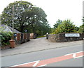
Entrance drive to Woodfield Park Funeral Home, Penmaen
Viewed across the main road through Penmaen. The funeral home is about 200 metres away.
Image: © Jaggery
Taken: 8 Aug 2012
0.12 miles
8
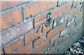
Ordnance Survey Cut Mark
This OS cut mark can be found on No1 Oakdale Terrace. It marks a point 194.731m above mean sea level.
Image: © Adrian Dust
Taken: 9 Feb 2021
0.12 miles
9
Bat bridge, Penmaen
The bat bridge is a pole on either site of the road with a line of netting run between them.
It was installed here, across the main road through Penmaen, in 2004.
Bats don't fly in the open, but usually follow hedge and tree lines. Even something as apparently trivial as the removal of a hedge can disrupt their flight. Bats stay in vegetation to avoid predators, crossing roads at points where trees either side create a canopy, as here.
The need for the bat bridge arose following the demolition of a nearby old railway bridge, part of a bat route, during the building of Sirhowy Enterprise Way.
Image: © Jaggery
Taken: 8 Aug 2012
0.12 miles
10
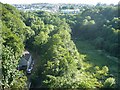
Sirhowy Valley
The view looking south from Image The roadway at the bottom left is part of the Sirhowy Valley Walk long distance footpath. The Sirhowy River is hidden in the trees to the right. Blackwood can be seen in the distance.
Image: © Robin Drayton
Taken: 3 Jul 2008
0.12 miles