IMAGES TAKEN NEAR TO
Central Avenue, BLACKWOOD, NP12 0DX
Introduction
This page details the photographs taken nearby to Central Avenue, NP12 0DX by members of the Geograph project.
The Geograph project started in 2005 with the aim of publishing, organising and preserving representative images for every square kilometre of Great Britain, Ireland and the Isle of Man.

There are currently over 7.5m images from over14,400 individuals and you can help contribute to the project by visiting https://www.geograph.org.uk
Image Map
Images are licensed for reuse under creativecommons.org/licenses/by-sa/2.0
Notes
- Clicking on the map will re-center to the selected point.
- The higher the marker number, the further away the image location is from the centre of the postcode.
Image Listing (54 Images Found)
Images are licensed for reuse under creativecommons.org/licenses/by-sa/2.0
Image
Details
Distance
1
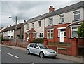
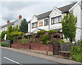
Central Avenue houses, Oakdale
Viewed from opposite Villagers. http://www.geograph.org.uk/photo/3075813
Image: © Jaggery
Taken: 8 Aug 2012
0.01 miles
2
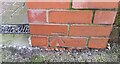
Ordnance Survey Cut Mark
This OS cut mark can be found on the wall of the old Club building. It marks a point 218.310m above mean sea level.
Image: © Adrian Dust
Taken: 9 Feb 2021
0.04 miles
3
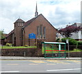
Oakdale : St David's Church, Penmaen
Church in Wales Church located in Central Avenue, Oakdale.
Without a knowledge of local history, the name of the church is confusing, because it is in the centre of Oakdale, some distance from Penmaen. When the original St David's Church opened in 1855, Oakdale did not exist. See the notes here. http://www.geograph.org.uk/photo/3075744
Image: © Jaggery
Taken: 8 Aug 2012
0.05 miles
4
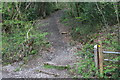
Footpath to Oakdale from the Rhiw
Woodland path.
Image: © M J Roscoe
Taken: 8 May 2016
0.06 miles
5
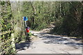
Path & road junction on The Rhiw
The No Through Road sign is for the road to the left. Across The Rhiw a footpath Image ascends the hillside, a continuation of the path (behind the camera) from Image
Image: © M J Roscoe
Taken: 15 Apr 2020
0.06 miles
6
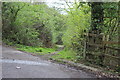
Field footpath below Oakdale School
Start of unsigned path from The Rhiw to Penmaen Estate.
Image: © M J Roscoe
Taken: 8 May 2016
0.08 miles
7
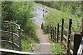
Footpath down to B4251
Stepped path from old minor road to road (Yard Coal Rise) on former railway track.
Image: © M J Roscoe
Taken: 8 May 2016
0.09 miles
8
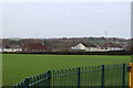
Oakdale Recreation Ground
Football field with, behind, St David's Church on Central Avenue.
Image: © M J Roscoe
Taken: 29 Oct 2015
0.09 miles
9
Villagers, Oakdale
Located in Central Avenue, Villagers is a small bar and restaurant specialising in Thai, Cantonese, Malaysian and Indian dishes, with Mediterranean and English alternatives.
Image: © Jaggery
Taken: 8 Aug 2012
0.09 miles
10
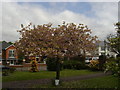
Cherry Tree, St David's Church, Oakdale
Cherry (probably Japanese) tree in grounds of church (out of sight to left); photographed as part of a survey of cherry trees, hence the clipboard at the base of the tree.
Image: © M J Roscoe
Taken: 20 May 2010
0.09 miles