IMAGES TAKEN NEAR TO
Central Avenue, BLACKWOOD, NP12 0DU
Introduction
This page details the photographs taken nearby to Central Avenue, NP12 0DU by members of the Geograph project.
The Geograph project started in 2005 with the aim of publishing, organising and preserving representative images for every square kilometre of Great Britain, Ireland and the Isle of Man.

There are currently over 7.5m images from over14,400 individuals and you can help contribute to the project by visiting https://www.geograph.org.uk
Image Map
Images are licensed for reuse under creativecommons.org/licenses/by-sa/2.0
Notes
- Clicking on the map will re-center to the selected point.
- The higher the marker number, the further away the image location is from the centre of the postcode.
Image Listing (60 Images Found)
Images are licensed for reuse under creativecommons.org/licenses/by-sa/2.0
Image
Details
Distance
1
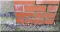
Ordnance Survey Cut Mark
This OS cut mark can be found on the wall of the old Club building. It marks a point 218.310m above mean sea level.
Image: © Adrian Dust
Taken: 9 Feb 2021
0.03 miles
2
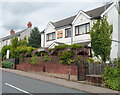
Villagers, Oakdale
Located in Central Avenue, Villagers is a small bar and restaurant specialising in Thai, Cantonese, Malaysian and Indian dishes, with Mediterranean and English alternatives.
Image: © Jaggery
Taken: 8 Aug 2012
0.03 miles
3
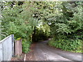
The Rhiw, Oakdale
Viewed from the northern edge of the Oakdale Comprehensive School site.
A lane named The Rhiw descends from the main road. Ahead is the Sirhowy valley and houses in Rhiw Syr Dafydd, which was a small rural hamlet that existed before the creation of Oakdale in the early 20th century.
Image: © Jaggery
Taken: 8 Aug 2012
0.04 miles
4
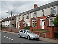
Central Avenue houses, Oakdale
Viewed from opposite Villagers. http://www.geograph.org.uk/photo/3075813
Image: © Jaggery
Taken: 8 Aug 2012
0.06 miles
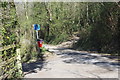
5
Field footpath below Oakdale School
Start of unsigned path from The Rhiw to Penmaen Estate.
Image: © M J Roscoe
Taken: 8 May 2016
0.06 miles
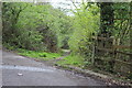
6
Woodland footpath above B4251
Partially realigned hillside footpath leading to a minor road, The Rhiw Image
Image: © M J Roscoe
Taken: 15 Apr 2020
0.08 miles
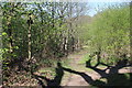
7
Footpath to Oakdale from the Rhiw
Woodland path.
Image: © M J Roscoe
Taken: 8 May 2016
0.08 miles
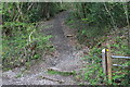
8
Path & road junction on The Rhiw
The No Through Road sign is for the road to the left. Across The Rhiw a footpath Image ascends the hillside, a continuation of the path (behind the camera) from Image
Image: © M J Roscoe
Taken: 15 Apr 2020
0.08 miles
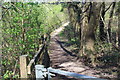
9
Footpath down to B4251
Stepped path from old minor road to road (Yard Coal Rise) on former railway track.
Image: © M J Roscoe
Taken: 8 May 2016
0.09 miles
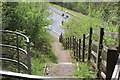
10
Footpath junction at top of bank by B4251
The path runs alongside the B4251 before descending steps to the road. The path to the right runs a few yards to a footpath gate Image
Image: © M J Roscoe
Taken: 15 Apr 2020
0.09 miles