IMAGES TAKEN NEAR TO
Bedwellty, BLACKWOOD, NP12 0BE
Introduction
This page details the photographs taken nearby to NP12 0BE by members of the Geograph project.
The Geograph project started in 2005 with the aim of publishing, organising and preserving representative images for every square kilometre of Great Britain, Ireland and the Isle of Man.

There are currently over 7.5m images from over14,400 individuals and you can help contribute to the project by visiting https://www.geograph.org.uk
Image Map
Images are licensed for reuse under creativecommons.org/licenses/by-sa/2.0
Notes
- Clicking on the map will re-center to the selected point.
- The higher the marker number, the further away the image location is from the centre of the postcode.
Image Listing (8 Images Found)
Images are licensed for reuse under creativecommons.org/licenses/by-sa/2.0
Image
Details
Distance
1
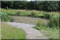
Pond at entrance to Aberbargoed Grasslands
Man-made pond near education centre with platform for 'dipping'.
Image: © M J Roscoe
Taken: 5 Jul 2020
0.13 miles
2
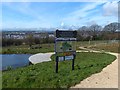
Information Board, Aberbargoed Grasslands
Located at an entrance to this National Nature Reserve.
This reserve is on a southwest-facing slope above the Rhymney Valley and is an area of semi-natural lowland grasslands of various types.
The reserve hosts an population of the rare Marsh Fritillary butterfly.
It was declared a National Nature Reserve in June 2012.
This view, from the highest point in the reserve, is looking towards the south-west over the Rhymney Valley towards Bargoed in the distance.
Image: © Robin Drayton
Taken: 1 Apr 2014
0.14 miles
3
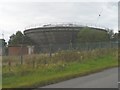
Ty Fry service reservoir (Welsh Water)
There are a number of reservoirs of this design in this area.
Image: © Robin Drayton
Taken: 27 Sep 2007
0.15 miles
4
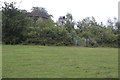
Owl box, Aberbargoed Grasslands NNR
Nest box near footpath gate on the boundary of the nature reserve.
Image: © M J Roscoe
Taken: 5 Jul 2020
0.16 miles
5
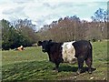
Cattle on Aberbargoed Grasslands
Controlled cattle grazing has been introduced on this National Nature Reserve in order to maintain the right conditions for the rare Marsh Fritillary butterflies.
The breed in the foreground is a Belted Galloway.
Image: © Robin Drayton
Taken: 1 Apr 2014
0.17 miles
6
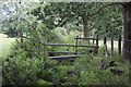
Footbridge in Aberbargoed Grasslands NNR
Wooden bridge over small, mostly dry, stream at field boundary.
Image: © M J Roscoe
Taken: 5 Jul 2020
0.18 miles
7
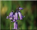
Bluebells
Bluebells in Aberbargoed grassland.
Image: © Rob Jones
Taken: 7 May 2018
0.19 miles
8
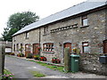
Tynewydd converted barns.
This is part of a group of houses which appear to have been developed from a farm. Note the row of holes on the front of the closest building which appear to be the remains of an old dove-cote. The 'front' of this house is the end of what was once a large barn which had its main opening on the road to the right of this picture.
Image: © Jessica Aidley
Taken: 5 Jul 2007
0.24 miles