IMAGES TAKEN NEAR TO
Gladstone Street, NEWPORT, NP11 7PN
Introduction
This page details the photographs taken nearby to Gladstone Street, NP11 7PN by members of the Geograph project.
The Geograph project started in 2005 with the aim of publishing, organising and preserving representative images for every square kilometre of Great Britain, Ireland and the Isle of Man.

There are currently over 7.5m images from over14,400 individuals and you can help contribute to the project by visiting https://www.geograph.org.uk
Image Map
Images are licensed for reuse under creativecommons.org/licenses/by-sa/2.0
Notes
- Clicking on the map will re-center to the selected point.
- The higher the marker number, the further away the image location is from the centre of the postcode.
Image Listing (123 Images Found)
Images are licensed for reuse under creativecommons.org/licenses/by-sa/2.0
Image
Details
Distance
1
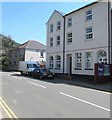
Tredegar House, Gladstone Street, Crosskeys
Flats in a recently-converted former pub viewed in May 2018.
The pub was the Monkey, seen here https://www.geograph.org.uk/photo/1891323 boarded-up in May 2010.
Image: © Jaggery
Taken: 23 May 2018
0.01 miles
2

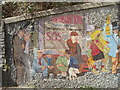
Wall mosaic, off Gladstone Street, Crosskeys
Image: © Colin Park
Taken: 19 May 2007
0.01 miles
3
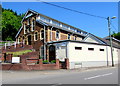
Crosskeys Pentecostal Church and hall
Viewed across Gladstone Street from the corner of Tredegar Street.
The church was built in the early 20th century in the Subclassical style.
Image: © Jaggery
Taken: 23 May 2018
0.02 miles
4
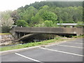
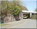
Bridge across the Ebbw, Crosskeys
The bridge carries Gladstone Street over the Ebbw river.
Image: © Jaggery
Taken: 26 May 2010
0.02 miles
5
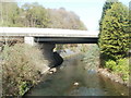
A467 river bridge, Cross Keys
The bridge carrying the A467 over the Ebbw River, viewed from the Gladstone Street river bridge. http://www.geograph.org.uk/photo/1891331
Image: © Jaggery
Taken: 10 Apr 2011
0.02 miles
6
Lane to Pandy Park, Crosskeys
An unnamed lane connects Pandy Park (the home ground of Crosskeys rugby club) with Gladstone Road behind the camera. http://www.geograph.org.uk/photo/2368037 to a closer view of the mural on the wall of the A467 bridge.
Image: © Jaggery
Taken: 10 Apr 2011
0.02 miles
7
Mural, A467 bridge, Crosskeys
Part of a mural http://www.geograph.org.uk/photo/2368028 alongside a lane from Gladstone Street to Pandy Park.
Image: © Jaggery
Taken: 10 Apr 2011
0.02 miles
8
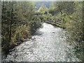
Ebbw River downstream from the edge of Pandy Park, Crosskeys
The sun-dappled, swirling river on this side of a bridge carrying an access road to Pandy Park rugby ground contrasts with the placid river on the other side. http://www.geograph.org.uk/photo/2419138
Image: © Jaggery
Taken: 10 Apr 2011
0.02 miles
9
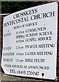
Information board outside Crosskeys Pentecostal Church
On display on the left here https://www.geograph.org.uk/photo/5784755 in May 2018.
Image: © Jaggery
Taken: 23 May 2018
0.02 miles
10
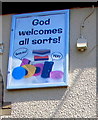
God welcomes all sorts, Crosskeys Pentecostal Church
On the wall near the brown door here. https://www.geograph.org.uk/photo/5784755
Image: © Jaggery
Taken: 23 May 2018
0.02 miles