IMAGES TAKEN NEAR TO
Gladstone Street, NEWPORT, NP11 7PA
Introduction
This page details the photographs taken nearby to Gladstone Street, NP11 7PA by members of the Geograph project.
The Geograph project started in 2005 with the aim of publishing, organising and preserving representative images for every square kilometre of Great Britain, Ireland and the Isle of Man.

There are currently over 7.5m images from over14,400 individuals and you can help contribute to the project by visiting https://www.geograph.org.uk
Image Map
Images are licensed for reuse under creativecommons.org/licenses/by-sa/2.0
Notes
- Clicking on the map will re-center to the selected point.
- The higher the marker number, the further away the image location is from the centre of the postcode.
Image Listing (230 Images Found)
Images are licensed for reuse under creativecommons.org/licenses/by-sa/2.0
Image
Details
Distance
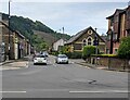
1
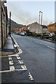
SW along Gladstone Street, Crosskeys
From the corner of Salisbury Street.
Image: © Jaggery
Taken: 20 Dec 2022
0.01 miles
2
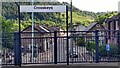
Crosskeys - Gladstone Street from the railway station
Image: © Peter Whatley
Taken: 31 May 2022
0.01 miles
3
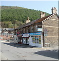
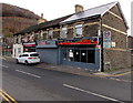
Three shops, Gladstone Street Crosskeys
The shops are at the NE end of Gladstone Street, facing Woodward Road near the corner of Risca Road.
Nearest the camera is Balti Nite, Indian cuisine.
Furthest away is K & S Newsagents.
The middle shop has To Let signs in the windows. The shop name shows Deli Stop. A previous occupant was Pezzetti Angling Supplies.
Image: © Jaggery
Taken: 10 Apr 2011
0.03 miles
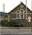
4
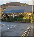
Former church, Gladstone Street, Crosskeys
Viewed from Salisbury Street in December 2022. This used to be St Catherine of Alexandria Church, seen here https://www.geograph.org.uk/photo/1930204 in 2010.
The building was used as a community centre after it ceased to be a place of worship. The community centre closed in December 2017.
Image: © Jaggery
Taken: 20 Dec 2022
0.03 miles
5
SW along Gladstone Street, Crosskeys
Viewed across the B4591 Risca Road.
Image: © Jaggery
Taken: 5 May 2022
0.04 miles
6
NW along Salisbury Street, Crosskeys
Towards Gladstone Street and a former church. https://www.geograph.org.uk/photo/7367343
Image: © Jaggery
Taken: 20 Dec 2022
0.04 miles
7
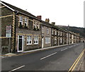
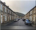
Long row of houses, Gladstone Street, Crosskeys
Extending for 110 metres from Salisbury Street on the left to Cobden Street.
Image: © Jaggery
Taken: 20 Nov 2019
0.04 miles
8
Woodward Road side of St Catherine's Church, Crosskeys
The northeast side of the church building in Gladstone Street.
https://www.geograph.org.uk/photo/6325586 to a closer view of the soldier silhouettes.
Image: © Jaggery
Taken: 20 Nov 2019
0.04 miles
9
Naz Spice, 8 Gladstone Street, Crosskeys
Indian cuisine takeaway on the corner of Salisbury Street.
Image: © Jaggery
Taken: 20 Nov 2019
0.04 miles
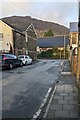
10
Bright Street, Crosskeys
From Salisbury Street along Bright Street towards Cobden Street.
Image: © Jaggery
Taken: 20 Dec 2022
0.04 miles