IMAGES TAKEN NEAR TO
Beech Terrace, NEWPORT, NP11 7NP
Introduction
This page details the photographs taken nearby to Beech Terrace, NP11 7NP by members of the Geograph project.
The Geograph project started in 2005 with the aim of publishing, organising and preserving representative images for every square kilometre of Great Britain, Ireland and the Isle of Man.

There are currently over 7.5m images from over14,400 individuals and you can help contribute to the project by visiting https://www.geograph.org.uk
Image Map
Images are licensed for reuse under creativecommons.org/licenses/by-sa/2.0
Notes
- Clicking on the map will re-center to the selected point.
- The higher the marker number, the further away the image location is from the centre of the postcode.
Image Listing (11 Images Found)
Images are licensed for reuse under creativecommons.org/licenses/by-sa/2.0
Image
Details
Distance
1
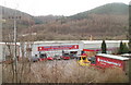
Gerry Jones Transport, Cwmcarn
Viewed from an A467 footbridge. http://www.geograph.org.uk/photo/2261971
The premises of Gerry Jones Transport are at Unit 25, Prince of Wales Industrial Estate.
Image: © Jaggery
Taken: 7 Feb 2011
0.16 miles
2
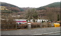
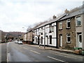
High ground and higher ground viewed from Commercial Road, Cwmcarn
The view SSW from the Old Swan pub. http://www.geograph.org.uk/photo/2261921
A plateau of high land is between two higher hills.
Image: © Jaggery
Taken: 7 Feb 2011
0.17 miles
4
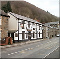
Old Swan to let, Cwmcarn
Boarded-up pub at 58 Commercial Road, Cwmcarn, just south of the Abercarn boundary. A prominent board on the wall of the building announces that it is to let, free of tie.
Some sources locate the pub in Abercarn, but the pub is on the Cwmcarn side of a boundary sign on the adjacent A467.
Image: © Jaggery
Taken: 7 Feb 2011
0.22 miles
5
Old Swan bus stops, Cwmcarn
The bus stops are on Commercial Road (B4591). The bus stop for southbound journeys is alongside the boarded-up Old Swan pub. http://www.geograph.org.uk/photo/2261921 The stop for northbound journeys is adjacent to the A467.
Image: © Jaggery
Taken: 7 Feb 2011
0.22 miles
6
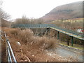
A467 footbridge, Cwmcarn
The footbridge leads from Commercial Road (B4591) to the west side of the A467.
Image: © Jaggery
Taken: 7 Feb 2011
0.22 miles
7
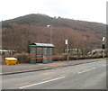
Bus shelter with a hilly backdrop, Cwmcarn
The shelter and bus stop are on Commercial Road, opposite the boarded-up Old Swan pub. http://www.geograph.org.uk/photo/2261921
The view is towards high ground on Craig y Crochan.
Image: © Jaggery
Taken: 7 Feb 2011
0.22 miles
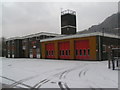
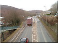
8
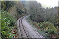
Ebbw Valley railway, Cwmcarn
Railway line north to Newbridge, seen from road bridge which here forms part of the Raven Walk on the outskirts of Cwmcarn.
Image: © M J Roscoe
Taken: 26 Oct 2016
0.25 miles
9
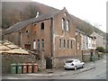
Former Pentecostal Full Gospel Mission Chapel, Abercarn
Derelict chapel on Commercial Road (B4591), Abercarn.
Image: © Jaggery
Taken: 7 Feb 2011
0.25 miles
10
A467 north of a footbridge, Cwmcarn
The view towards Abercarn from a footbridge. http://www.geograph.org.uk/photo/2261971
Image: © Jaggery
Taken: 7 Feb 2011
0.25 miles