IMAGES TAKEN NEAR TO
Newport Road, NEWPORT, NP11 7NE
Introduction
This page details the photographs taken nearby to Newport Road, NP11 7NE by members of the Geograph project.
The Geograph project started in 2005 with the aim of publishing, organising and preserving representative images for every square kilometre of Great Britain, Ireland and the Isle of Man.

There are currently over 7.5m images from over14,400 individuals and you can help contribute to the project by visiting https://www.geograph.org.uk
Image Map
Images are licensed for reuse under creativecommons.org/licenses/by-sa/2.0
Notes
- Clicking on the map will re-center to the selected point.
- The higher the marker number, the further away the image location is from the centre of the postcode.
Image Listing (69 Images Found)
Images are licensed for reuse under creativecommons.org/licenses/by-sa/2.0
Image
Details
Distance
1
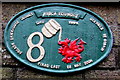
Risca Foundry final cast nameplate on a Newport Road house, Cwmcarn
The nameplate of number 8 Newport Road http://www.geograph.org.uk/photo/5246667 shows RISCA FOUNDRY FINAL CAST 28 MAY 2004.
Image: © Jaggery
Taken: 7 Jan 2017
0.01 miles
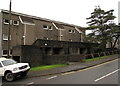
2
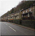
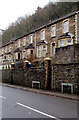
Houses above the B4591 Newport Road, Cwmcarn
The semi-detached houses on the east side of Newport Road are set a couple of metres above road level.
They face trees and a fence above the A467.
Image: © Jaggery
Taken: 7 Jan 2017
0.01 miles
3
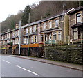
Newport Road houses, Cwmcarn
Click http://www.geograph.org.uk/photo/5246663 for a closer view of the green nameplate on the right, a Risca Foundry final cast from May 2004.
Image: © Jaggery
Taken: 7 Jan 2017
0.02 miles
4
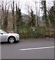
Newport Road electricity substation, Cwmcarn
The Western Power Distribution electricity substation is in a fenced enclosure on the west side of the B4591 Newport Road. Its identifier is NEWPORT RD SW SITE CWMCARN S/S No. 55-2226.
Image: © Jaggery
Taken: 7 Jan 2017
0.03 miles
5
Ordnance Survey Cut Mark
This OS cut mark can be found on the wall of No22 Newport Road. It marks a point 97.610m above mean sea level.
Image: © Adrian Dust
Taken: 11 May 2019
0.05 miles
6
From Newport Road to Commercial Road, Cwmcarn
Viewed across the B4591. The Newport Road name sign is on the right.
The Commercial Road name sign is a few metres to the left of it.
Image: © Jaggery
Taken: 7 Jan 2017
0.06 miles
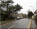
7
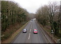
A467 south of a footbridge, Cwmcarn
The view SSE from a footbridge http://www.geograph.org.uk/photo/2261971 connecting with Commercial Road.
Image: © Jaggery
Taken: 7 Feb 2011
0.08 miles
8
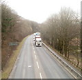
South along the A467, Cwmcarn
Viewed from this footbridge. http://www.geograph.org.uk/photo/5245317
Image: © Jaggery
Taken: 20 Dec 2016
0.08 miles
9
Edwardsville, Cwmcarn
Part of an area of housing named Edwardsville on the west side of the B4591 Newport Road.
Image: © Jaggery
Taken: 7 Jan 2017
0.09 miles
10
Edwardsville bus stop, Cwmcarn
The bus stop on the right is alongside Newport Road, opposite houses in Edwardsville. http://www.geograph.org.uk/photo/5246609
This side of the road for buses to Crosskeys, Risca and Newport.
Image: © Jaggery
Taken: 7 Jan 2017
0.09 miles