IMAGES TAKEN NEAR TO
Pond Row, NEWPORT, NP11 7LX
Introduction
This page details the photographs taken nearby to Pond Row, NP11 7LX by members of the Geograph project.
The Geograph project started in 2005 with the aim of publishing, organising and preserving representative images for every square kilometre of Great Britain, Ireland and the Isle of Man.

There are currently over 7.5m images from over14,400 individuals and you can help contribute to the project by visiting https://www.geograph.org.uk
Image Map
Images are licensed for reuse under creativecommons.org/licenses/by-sa/2.0
Notes
- Clicking on the map will re-center to the selected point.
- The higher the marker number, the further away the image location is from the centre of the postcode.
Image Listing (155 Images Found)
Images are licensed for reuse under creativecommons.org/licenses/by-sa/2.0
Image
Details
Distance
1
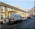
Centregreat van with a Versalift, Newport Road, Cwmcarn
The van has a Versalift, an access platform which can be extended for working high above street level, such as on street lights.
Image: © Jaggery
Taken: 29 Dec 2016
0.02 miles
2
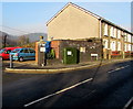
Newport Road telecomms cabinet, Cwmcarn
Viewed across the B4591 Newport Road in late December 2016.
A notice on the cabinet states that fibre broadband is here.
Image: © Jaggery
Taken: 29 Dec 2016
0.03 miles
3
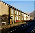
Row of houses, Newport Road, Cwmcarn
On the west side of the B4591 Newport Road.
Image: © Jaggery
Taken: 29 Dec 2016
0.04 miles
4
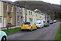
Feeder Row, Cwmcarn
A cul-de-sac of well maintained terraced houses overlooking a playing field. The road forms part of the Raven Walk.
Image: © M J Roscoe
Taken: 31 Mar 2017
0.04 miles
5
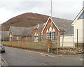
Cwmcarn Primary School
Viewed across Newport Road (B4591).
Image: © Jaggery
Taken: 7 Feb 2011
0.05 miles
6
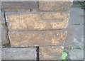
Ordnance Survey Cut Mark
This OS cut mark can be found on the wall of NO5 Twyncarn Terrace. It marks a point 91.483m above mean sea level.
Image: © Adrian Dust
Taken: 11 May 2019
0.06 miles
7
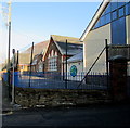
South side of Cwmcarn Primary School, Cwmcarn
On the east side of Newport Road. The school is closed today, December 29th 2016, during the Christmas and New Year holidays. At 11am, hoar frost remains on areas of roof not yet reached by the rays of the winter sun.
Image: © Jaggery
Taken: 29 Dec 2016
0.06 miles
8
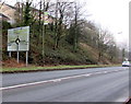
A467 directions sign, Cwmcarn
Facing southbound traffic on the A467 on the approach to this roundabout. http://www.geograph.org.uk/photo/5236574
Image: © Jaggery
Taken: 20 Dec 2016
0.06 miles
9
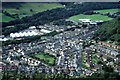
Cwmcarn
View of the town taken from Cwmcarn Scenic Drive
Image: © Darius Khan
Taken: 10 Aug 2002
0.07 miles
10
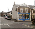
Pharaoh Fasteners, Cwmcarn
Ironmongers and DIY shop located on the corner of Ivor Street and Caradoc Street.
Image: © Jaggery
Taken: 7 Feb 2011
0.07 miles