IMAGES TAKEN NEAR TO
Alexandra Road, NEWPORT, NP11 7LA
Introduction
This page details the photographs taken nearby to Alexandra Road, NP11 7LA by members of the Geograph project.
The Geograph project started in 2005 with the aim of publishing, organising and preserving representative images for every square kilometre of Great Britain, Ireland and the Isle of Man.

There are currently over 7.5m images from over14,400 individuals and you can help contribute to the project by visiting https://www.geograph.org.uk
Image Map
Images are licensed for reuse under creativecommons.org/licenses/by-sa/2.0
Notes
- Clicking on the map will re-center to the selected point.
- The higher the marker number, the further away the image location is from the centre of the postcode.
Image Listing (49 Images Found)
Images are licensed for reuse under creativecommons.org/licenses/by-sa/2.0
Image
Details
Distance
1
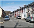
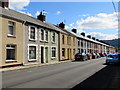
Alexandra Road houses, Ynysddu
A view to the NNW.
Image: © Jaggery
Taken: 7 Apr 2011
0.02 miles
2
Northern edge of Alexandra Road, Ynysddu
Viewed across Newport Road.
Image: © Jaggery
Taken: 7 Apr 2011
0.02 miles
3
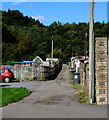
Back lane in Ynysddu
Between the backs of Alexandra Road houses and allotments.
Image: © Jaggery
Taken: 24 Sep 2018
0.03 miles
4

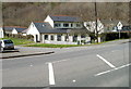
Northern boundary of Ynysddu
Newport Road, from Pontllanfraith, reaches the Sirhowy valley village of Ynysddu, pronounced un-iss-thee.
Image: © Jaggery
Taken: 7 Apr 2011
0.06 miles
5
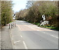
End of 30mph speed limit at the edge of Ynysddu
Heading north towards Pontllanfraith, Newport Road leaves the northern edge of the Sirhowy village of Ynysddu. The speed limit increases from 30mph to the National Speed limit.
Image: © Jaggery
Taken: 7 Apr 2011
0.06 miles
6
Alexandra Road houses, Ynysddu
A similar long row of houses is on the camera side of Alexandra Road.
Image: © Jaggery
Taken: 24 Sep 2018
0.06 miles
7
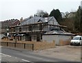
Major exterior work on The Black Prince, Ynysddu
This March 2012 view shows work in progress on The Black Prince. There have been structural alterations since this view http://www.geograph.org.uk/photo/2840979 taken nearly a year earlier. Though the pub sign http://www.geograph.org.uk/photo/2847943 is still in place, perhaps the (former?) pub building is being converted into a private dwelling...
Image: © Jaggery
Taken: 14 Mar 2012
0.08 miles
8
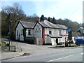
The Black Prince, Ynysddu viewed from the SW
Pub alongside the main road through the Sirhowy valley village. http://www.geograph.org.uk/photo/2840977 to another view.
http://www.geograph.org.uk/photo/2847943 to the pub name sign.
Image: © Jaggery
Taken: 7 Apr 2011
0.08 miles
9
The Black Prince, Ynysddu viewed from the NW
Pub alongside the main road through the Sirhowy valley village. http://www.geograph.org.uk/photo/2840979 to another view.
http://www.geograph.org.uk/photo/2847943 to the pub name sign.
Image: © Jaggery
Taken: 7 Apr 2011
0.08 miles
10
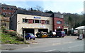
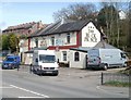
Meredith Bros, Ynysddu
One name sign shows Meredith Bros, another shows D.B.Meredith. The business provides vehicle-related services such as MoT tests, repairs & servicing and car sales.
Image: © Jaggery
Taken: 7 Apr 2011
0.08 miles