IMAGES TAKEN NEAR TO
John Street, NEWPORT, NP11 7JT
Introduction
This page details the photographs taken nearby to John Street, NP11 7JT by members of the Geograph project.
The Geograph project started in 2005 with the aim of publishing, organising and preserving representative images for every square kilometre of Great Britain, Ireland and the Isle of Man.

There are currently over 7.5m images from over14,400 individuals and you can help contribute to the project by visiting https://www.geograph.org.uk
Image Map
Images are licensed for reuse under creativecommons.org/licenses/by-sa/2.0
Notes
- Clicking on the map will re-center to the selected point.
- The higher the marker number, the further away the image location is from the centre of the postcode.
Image Listing (98 Images Found)
Images are licensed for reuse under creativecommons.org/licenses/by-sa/2.0
Image
Details
Distance
1
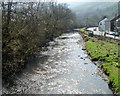
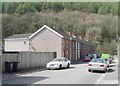
Sirhowy and Station Avenue, Ynysddu
Viewed from this http://www.geograph.org.uk/photo/2841074 bridge. The river flows alongside Station Avenue.
Image: © Jaggery
Taken: 7 Apr 2011
0.03 miles
2
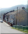
Station Avenue, Ynysddu
There are houses on only one side of the street here. The Sirhowy http://www.geograph.org.uk/photo/2841082 flows past the opposite side.
The street's name recalls Ynysddu railway station, which closed in 1960.
Image: © Jaggery
Taken: 7 Apr 2011
0.03 miles
3
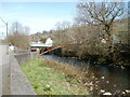
Pipe bridge across the Sirhowy
A spiked barrier on the pipe bridge is designed to deter anyone using it to cross the river - though why do so anyway, as there is a road bridge nearby! Viewed from Station Avenue.
Image: © Jaggery
Taken: 7 Apr 2011
0.03 miles
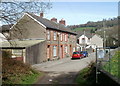
4
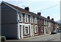
High Street houses, Ynysddu
The High Street in Ynysddu is mostly residential, with few shops.
Image: © Jaggery
Taken: 7 Apr 2011
0.03 miles
5
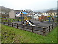
Children's play area, Ynysddu
Located near Ynysddu Hotel. http://www.geograph.org.uk/photo/2841064
Image: © Jaggery
Taken: 14 Mar 2012
0.03 miles
6
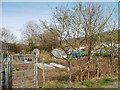
Ynysddu allotments
Located on the east bank of the Sirhowy River.
Image: © Jaggery
Taken: 7 Apr 2011
0.04 miles
7
Southern end of Station Avenue, Ynysddu
Viewed from the edge of a track http://www.geograph.org.uk/photo/2841113 into woodland.
Image: © Jaggery
Taken: 7 Apr 2011
0.04 miles
8
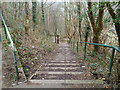
Steps down from a cycleway near Ynysddu
The steps are one of two routes connecting National Cycle Network route 47 through the Sirhowy Valley Country Park with residential Ynysddu. The other route is via a lane that passes under this bridge.http://www.geograph.org.uk/photo/2848049
Image: © Jaggery
Taken: 14 Mar 2012
0.05 miles
9
Bridge Street, Ynysddu
Looking west from the Station Avenue end of the street.
Image: © Jaggery
Taken: 7 Apr 2011
0.05 miles
10
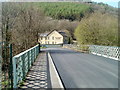
Bridge across the Sirhowy, Ynysddu
Viewed from High Street looking towards the Ynysddu Hotel. http://www.geograph.org.uk/photo/2841064
Image: © Jaggery
Taken: 7 Apr 2011
0.05 miles