IMAGES TAKEN NEAR TO
High Street, NEWPORT, NP11 7JJ
Introduction
This page details the photographs taken nearby to High Street, NP11 7JJ by members of the Geograph project.
The Geograph project started in 2005 with the aim of publishing, organising and preserving representative images for every square kilometre of Great Britain, Ireland and the Isle of Man.

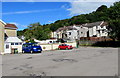
There are currently over 7.5m images from over14,400 individuals and you can help contribute to the project by visiting https://www.geograph.org.uk
Image Map
Images are licensed for reuse under creativecommons.org/licenses/by-sa/2.0
Notes
- Clicking on the map will re-center to the selected point.
- The higher the marker number, the further away the image location is from the centre of the postcode.
Image Listing (105 Images Found)
Images are licensed for reuse under creativecommons.org/licenses/by-sa/2.0
Image
Details
Distance
2
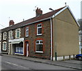
Unnamed shop, Ynysddu
There is no name on the shop at 18 High Street, the premises with its awning partly extended.
A clue as to its use is the Fleur de Lys Pies sign on the building, so it is probably a fish and chip shop.
Image: © Jaggery
Taken: 14 Mar 2012
0.00 miles
4
High Street bus stop and shelter, Ynysddu
In September 2018 this is a stop on Stagecoach bus route 56 to Newport.
Scheduled journey time to Market Square bus station in Newport is 36 minutes.
Image: © Jaggery
Taken: 24 Sep 2018
0.01 miles
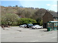
5
High Street car park, Ynysddu
Free car park on the east side of High Street.
Image: © Jaggery
Taken: 24 Sep 2018
0.02 miles
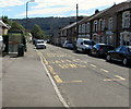
6
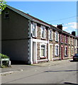
Houses at northern end of High Street, Ynysddu
The HIGH STREET name sign is on the left.
Image: © Jaggery
Taken: 24 Sep 2018
0.03 miles
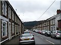
7
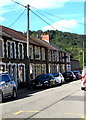
On-street parking, High Street, Ynysddu
High Street Ynysddu is mainly residential, with few shops.
The main road through the village is the B4251.
Image: © Jaggery
Taken: 24 Sep 2018
0.03 miles
8
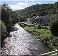
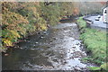
Downstream along the Sirhowy, Ynysddu
Looking south from this https://www.geograph.org.uk/photo/6207024 road bridge. Station Avenue is on the right.
The Sirhowy is a major tributary of the Ebbw. The rivers meet in Crosskeys https://www.geograph.org.uk/photo/2351055
Image: © Jaggery
Taken: 24 Sep 2018
0.04 miles
9
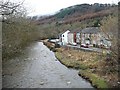
River Sirhowy, Station Avenue, Ynysddu
River downstream from Ynysddu Bridge Image flowing alongside Station Avenue which is protected by a concrete wall.
Image: © M J Roscoe
Taken: 3 Nov 2016
0.04 miles
10
Sirhowy River, Ynysddu
Looking downstream with Station Avenue on the right.
Image: © Robin Drayton
Taken: 20 Mar 2010
0.05 miles