IMAGES TAKEN NEAR TO
Graig View, NEWPORT, NP11 7JG
Introduction
This page details the photographs taken nearby to Graig View, NP11 7JG by members of the Geograph project.
The Geograph project started in 2005 with the aim of publishing, organising and preserving representative images for every square kilometre of Great Britain, Ireland and the Isle of Man.

There are currently over 7.5m images from over14,400 individuals and you can help contribute to the project by visiting https://www.geograph.org.uk
Image Map
Images are licensed for reuse under creativecommons.org/licenses/by-sa/2.0
Notes
- Clicking on the map will re-center to the selected point.
- The higher the marker number, the further away the image location is from the centre of the postcode.
Image Listing (73 Images Found)
Images are licensed for reuse under creativecommons.org/licenses/by-sa/2.0
Image
Details
Distance
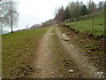
1
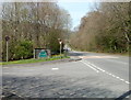
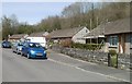
Southern boundary of Ynysddu
The road from Cwmfelinfach reaches the Sirhowy Valley village of Ynysddu (pronounced un-iss-thee).
Image: © Jaggery
Taken: 7 Apr 2011
0.00 miles
2
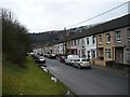
Graig View, Ynysddu
A cul-de-sac at the southern end of the village.
Image: © Robin Drayton
Taken: 20 Mar 2010
0.00 miles
3
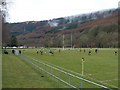
Football at Ynysddu
A dual purpose pitch at Ynysddu Rugby Football Club.
Image: © Robin Drayton
Taken: 20 Mar 2010
0.03 miles
5
Track to a disused quarry near Cwmfelinfach
Viewed through a locked gate to the east of St Theodore's church. http://www.geograph.org.uk/photo/2848417
Image: © Jaggery
Taken: 14 Mar 2012
0.06 miles
6
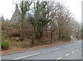
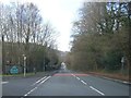
A glimpse of St Theodore's Church, Cwmfelinfach
The church http://www.geograph.org.uk/photo/2848351 can be seen from here, Maindee Road near the Ynysddu boundary, only when the trees are bare of leaves. Ahead, near the right edge of the view, is the turning for Commercial Road.
Image: © Jaggery
Taken: 14 Mar 2012
0.06 miles
7
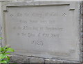
Foundation stone, St Theodore's Church, Cwmfelinfach
The inscription shows that the stone was laid on the 23rd day of September 1925.
The church http://www.geograph.org.uk/photo/2848351 is at the northern edge of Cwmfelinfach.
Image: © Jaggery
Taken: 14 Mar 2012
0.06 miles
8
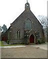
St Theodore's Church, Cwmfelinfach
The church is at the northern edge of Cwmfelinfach, near the junction of
Maindee Road and Commercial Road. Built in 1925, the Church in Wales church
is part of the Rectorial Benefice of Mynyddislwyn in the diocese of Monmouth.
Image: © Jaggery
Taken: 14 Mar 2012
0.06 miles
9
Graig View bungalows, Ynysddu
Located near an entrance to Nine Mile Point Welfare Grounds (behind the camera).
Image: © Jaggery
Taken: 7 Apr 2011
0.06 miles
10
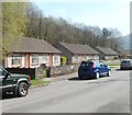
Bungalows, Graig View, Ynysddu
Viewed looking in the direction of an entrance to Nine Mile Point Welfare Grounds.
Image: © Jaggery
Taken: 7 Apr 2011
0.06 miles