IMAGES TAKEN NEAR TO
Stanley Street, NEWPORT, NP11 7HF
Introduction
This page details the photographs taken nearby to Stanley Street, NP11 7HF by members of the Geograph project.
The Geograph project started in 2005 with the aim of publishing, organising and preserving representative images for every square kilometre of Great Britain, Ireland and the Isle of Man.

There are currently over 7.5m images from over14,400 individuals and you can help contribute to the project by visiting https://www.geograph.org.uk
Image Map
Images are licensed for reuse under creativecommons.org/licenses/by-sa/2.0
Notes
- Clicking on the map will re-center to the selected point.
- The higher the marker number, the further away the image location is from the centre of the postcode.
Image Listing (80 Images Found)
Images are licensed for reuse under creativecommons.org/licenses/by-sa/2.0
Image
Details
Distance
1
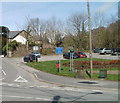
Cwmfelinfach car park and recycling area
On the corner of Maindee Road (B4251) and Commercial Road.
Image: © Jaggery
Taken: 7 Apr 2011
0.02 miles
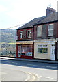
2
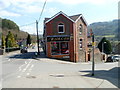
Hair.Com, Cwmfelinfach
Hair.Com at 1 Bridge View, on the corner of Stanley Street, describes itself as a "Colour Lounge" (hair salon).
Image: © Jaggery
Taken: 7 Apr 2011
0.02 miles
3
Cwmfelinfach Clinic
The Gwent Healthcare NHS Trust clinic is on the corner of Stanley Street and New Road (B4251).
Image: © Jaggery
Taken: 7 Apr 2011
0.02 miles
4
Cwmfelinfach War Memorial
Whereas most British War Memorials commemorate the local people who were killed in wars, this one http://www.geograph.org.uk/photo/1575082 is in meemory of all those who lost their lives in the battles for freedom.
Image: © Jaggery
Taken: 7 Apr 2011
0.02 miles
5
Dragon City, Cwmfelinfach
Takeaway at 4 Bridge View. The name board shows "Chinese & English meals to take away".
Image: © Jaggery
Taken: 7 Apr 2011
0.02 miles
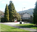
6
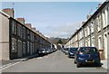
Islwyn Street, Cwmfelinfach
Looking north towards New Road (B4251).
Image: © Jaggery
Taken: 7 Apr 2011
0.04 miles
7
Forestier & Walkers Club, Cwmfelinfach
Conservative club, Islwyn Street. Various online references give the name as "Forestier Walker" but the nameboard shows Forestier & Walkers Club.
Image: © Jaggery
Taken: 7 Apr 2011
0.04 miles
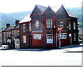
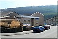
8
Cwmfelinfach Community Hall
Viewed from Islwyn Street.
Image: © Jaggery
Taken: 7 Apr 2011
0.04 miles
9
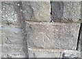
Ordnance Survey Cut Mark
This OS cut mark can be found on the stone post at the Pioneer Hotel. It marks a point 112.709m above mean sea level.
Image: © Adrian Dust
Taken: 23 Jun 2021
0.05 miles
10
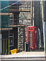
Cwmfelinfach: phone box and grit bin
A closer look at the telephone box standing outside Image
Image: © Chris Downer
Taken: 1 Mar 2014
0.05 miles