IMAGES TAKEN NEAR TO
Gelli-Unig Terrace, NEWPORT, NP11 7GF
Introduction
This page details the photographs taken nearby to Gelli-Unig Terrace, NP11 7GF by members of the Geograph project.
The Geograph project started in 2005 with the aim of publishing, organising and preserving representative images for every square kilometre of Great Britain, Ireland and the Isle of Man.

There are currently over 7.5m images from over14,400 individuals and you can help contribute to the project by visiting https://www.geograph.org.uk
Image Map
Images are licensed for reuse under creativecommons.org/licenses/by-sa/2.0
Notes
- Clicking on the map will re-center to the selected point.
- The higher the marker number, the further away the image location is from the centre of the postcode.
Image Listing (111 Images Found)
Images are licensed for reuse under creativecommons.org/licenses/by-sa/2.0
Image
Details
Distance
1
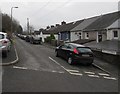
Gelli Unig Road, Pontywaun
South along Gelli Unig Road from the corner of Trinity Hill.
Image: © Jaggery
Taken: 17 Dec 2016
0.01 miles
2
Trinity Hill, Pontywaun
Viewed from near the corner http://www.geograph.org.uk/photo/2307979 of Garden Suburbs.
Image: © Jaggery
Taken: 7 Feb 2011
0.03 miles
3
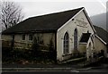
Trinity Congregational Church, Pontywaun
Located halfway up Gelli-unig Place. The church opened in 1870.
Image: © Jaggery
Taken: 7 Feb 2011
0.05 miles
4
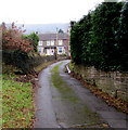
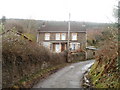
Houses near the top of Trinity Hill, Pontywaun
A name sign pointing this way shows GELLI UNIG PLACE 16-17.
Image: © Jaggery
Taken: 17 Dec 2016
0.05 miles
5
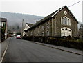
Trinity Congregational Church Sunday School, Pontywaun
The Sunday School was erected in 1911 on the east side of Trinity Congregational Church. http://www.geograph.org.uk/photo/5241441
The two buildings were jointly Grade II listed in 1998.
Image: © Jaggery
Taken: 17 Dec 2016
0.06 miles
6
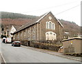
Grade II listed Trinity Congregational Church, Pontywaun
Located on a steep hillside above the valley of the Ebbw River, viewed across Trinity Hill. Opened in 1870, this was one of the churches built for the English speaking workers coming into the area, following the formation in 1862 of The Society for Promoting the Establishment and Support of the English Congregational Churches in South Wales and Monmouthshire. The church building was Grade II listed in 1998, together with the adjacent Sunday School. http://www.geograph.org.uk/photo/5241668
Image: © Jaggery
Taken: 17 Dec 2016
0.07 miles
7
Mount Pleasant Terrace, Pontywaun
The northern end of a long dead-end street on the east bank of a disused canal (the Crumlin Arm of the Monmouthshire & Brecon Canal).
Image: © Jaggery
Taken: 17 Dec 2016
0.07 miles
8
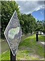
Crumlin Arm
Section of the Monmouthshire canal at Pontywaun.
Image: © Alan Hughes
Taken: 12 Jun 2022
0.07 miles
9
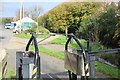
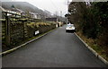
Towpath, Monmouthshire & Brecon Canal, Pontywaun
A squeeze stile on the Crumlin Arm of the canal where the path meets a minor road, Halls Road Terrace (left). The black gate in the centre Image restricts access to a slipway to the canal (right).
Image: © M J Roscoe
Taken: 2 Nov 2017
0.07 miles
10
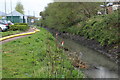
Partly drained Crumlin Arm of canal, Pontywaun
View north from camera in Image This section of the canal is being drained in order to remove accumulated silt. The yellow pipe on the towpath is carrying the water away from the camera.
Image: © M J Roscoe
Taken: 28 Apr 2021
0.07 miles