IMAGES TAKEN NEAR TO
Silver Street, NEWPORT, NP11 7FX
Introduction
This page details the photographs taken nearby to Silver Street, NP11 7FX by members of the Geograph project.
The Geograph project started in 2005 with the aim of publishing, organising and preserving representative images for every square kilometre of Great Britain, Ireland and the Isle of Man.

There are currently over 7.5m images from over14,400 individuals and you can help contribute to the project by visiting https://www.geograph.org.uk
Image Map
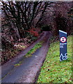
Images are licensed for reuse under creativecommons.org/licenses/by-sa/2.0
Notes
- Clicking on the map will re-center to the selected point.
- The higher the marker number, the further away the image location is from the centre of the postcode.
Image Listing (112 Images Found)
Images are licensed for reuse under creativecommons.org/licenses/by-sa/2.0
Image
Details
Distance
1
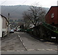
East along Silver Street, Pontywaun
From the B4591 Twyncarn Road along Silver Street towards North Road and Garden Suburbs.
Image: © Jaggery
Taken: 17 Dec 2016
0.01 miles
2
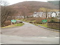
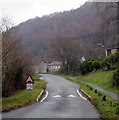
Entrance to Cwmcarn Forest Drive
Based on the positioning of a nearby Cwmcarn boundary sign, this is actually the northern edge of Pontywaun. Cwmcarn Forest Drive heads away from the B4591 (Twyncarn Road) towards the scenic delights of Cwmcarn Forest.
Image: © Jaggery
Taken: 7 Feb 2011
0.03 miles
3
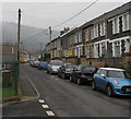
North along North Road, Pontywaun
From the corner of Castle Lane along North Road towards Silver Street.
Image: © Jaggery
Taken: 17 Dec 2016
0.04 miles
4
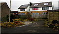
Houses on the north side of Castle Lane, Pontywaun
Behind an electricity substation and fence on the north side of Castle Lane.
Image: © Jaggery
Taken: 17 Dec 2016
0.04 miles
5
Speed bump on Cwmcarn Forest Drive
Painted white triangles draw attention to the speed bump alongside a 15mph speed limit sign.
Image: © Jaggery
Taken: 20 Dec 2016
0.04 miles
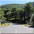
6
Entrance to Cwm Carn Scenic Drive
This was once the railway track up to Cwmcarn Colliery.
Image: © Robin Drayton
Taken: 8 Feb 2008
0.04 miles
7
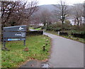
Western end of Cwmcarn Forest Drive
On the east side of the B4591 Twyncarn Road. The sign on the left shows that various facilities are three-quarters of a mile ahead.
Image: © Jaggery
Taken: 20 Dec 2016
0.04 miles
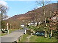
8
Cwmcarn Forest Drive, Pontywaun
On the east side of the B4591 Twyncarn Road in Pontywaun near the southern edge of Cwmcarn.
Image: © Jaggery
Taken: 22 Jun 2018
0.04 miles
9
Private lane near the western end of Cwmcarn Forest Drive
The bilingual sign on the right shows No Entry - Private and their Welsh equivalents. The lane is on the east side of the B4591 Twyncarn Road, a few metres from the western end of Cwmcarn Forest Drive. http://www.geograph.org.uk/photo/5235721
Image: © Jaggery
Taken: 20 Dec 2016
0.05 miles
10
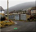
Castle Close lockup garages, Pontywaun
Viewed from Castle Lane.
Image: © Jaggery
Taken: 17 Dec 2016
0.05 miles