IMAGES TAKEN NEAR TO
Cwmcarn, NEWPORT, NP11 7EY
Introduction
This page details the photographs taken nearby to NP11 7EY by members of the Geograph project.
The Geograph project started in 2005 with the aim of publishing, organising and preserving representative images for every square kilometre of Great Britain, Ireland and the Isle of Man.

There are currently over 7.5m images from over14,400 individuals and you can help contribute to the project by visiting https://www.geograph.org.uk
Image Map
Images are licensed for reuse under creativecommons.org/licenses/by-sa/2.0
Notes
- Clicking on the map will re-center to the selected point.
- The higher the marker number, the further away the image location is from the centre of the postcode.
Image Listing (43 Images Found)
Images are licensed for reuse under creativecommons.org/licenses/by-sa/2.0
Image
Details
Distance
1
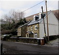
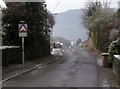
Nantcarn Road cottages, Cwmcarn
Diagonally opposite Reece's Terrace. http://www.geograph.org.uk/photo/5243574
Image: © Jaggery
Taken: 29 Dec 2016
0.01 miles
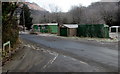
2
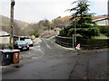
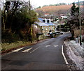
Unnamed road on the north side of Nantcarn Road, Cwmcarn
Viewed on December 29th 2016. A temporary sign on the right warns of ice.
Overnight hoar frost remains on many surfaces.
Image: © Jaggery
Taken: 29 Dec 2016
0.01 miles
3
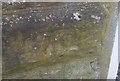
Ordnance Survey Cut Mark
This OS cut mark can be found on No3 Reeces Terrace. It marks a point 105.568m above mean sea level.
Image: © Adrian Dust
Taken: 11 May 2019
0.02 miles
4
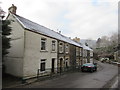
Reece's Terrace, Cwmcarn
Row of houses on the south side of Nantcarn Road.
Image: © Jaggery
Taken: 29 Dec 2016
0.02 miles
5
Warning sign - humps for 760 yds, Nantcarn Road, Cwmcarn
The first hump across Nantcarn Road is a few metres behind the sign.
Image: © Jaggery
Taken: 29 Dec 2016
0.02 miles
6
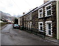
Reece's Terrace, Cwmcarn
Row of houses on the south side of Nantcarn Road.
Image: © Jaggery
Taken: 29 Dec 2016
0.02 miles
7
Nantcarn Road speed bump, Cwmcarn
Painted white triangles draw attention to the bump across Nantcarn Road.
Image: © Jaggery
Taken: 29 Dec 2016
0.02 miles
8
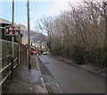
Leisure activities ahead, Nantcarn Road, Cwmcarn
This way to Cwmcarn Forest Drive which leads to a visitors' centre, campsite and mountain bike trails.
Image: © Jaggery
Taken: 29 Dec 2016
0.02 miles
9
Junction of Ramping Road and Nantcarn Road, Cwmcarn
A sign http://www.geograph.org.uk/photo/5243534 behind the camera warns of humps across Nantcarn Road to the right and left.
Image: © Jaggery
Taken: 29 Dec 2016
0.04 miles
10
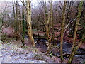
Nant Carn, Cwmcarn
Here below Nantcarn Road, Nant Carn is a tributary of the Ebbw River.
Image: © Jaggery
Taken: 29 Dec 2016
0.04 miles