1
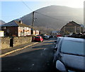
Wintry Edward Street, Cwmcarn
At 11:15am on December 29th 2016, overnight hoar frost remains on Edward Street roofs not yet reached by the direct rays of the sun, and on the car in the foreground.
Image: © Jaggery
Taken: 29 Dec 2016
0.02 miles
2
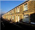
John Street houses, Cwmcarn
This part of John Street is opposite Cwmcarn Memorial Park.
Image: © Jaggery
Taken: 29 Dec 2016
0.02 miles
3
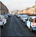
On-street parking in Edward Street, Cwmcarn
From the corner of Bernard Street and Nantcarn Road, Edward Street ascends towards John Street.
Image: © Jaggery
Taken: 29 Dec 2016
0.02 miles
4
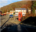
Doomed red phonebox on a Cwmcarn corner
On the corner of John Street and Edward Street, viewed on December 29th 2016.
Inside the box, a BT Payphone Kiosk Removal public notice is dated August 9th 2016. It states that this phonebox has had very little use over a significant period of time. BT therefore proposes to remove this phone box. There is a consultation period of 42 days from August 9th 2016. Please contact your Local Authority Planning Department if you have any comments. An 0800 number is given for information about the nearest alternative payphone and the name of the local authority.
Image: © Jaggery
Taken: 29 Dec 2016
0.03 miles
5
Ordnance Survey Cut Mark
This OS cut mark can be found on the wall of No11 & 12 Abercarn Fach. It marks a point 102.681m above mean sea level.
Image: © Adrian Dust
Taken: 11 May 2019
0.03 miles
6
Bernard Street, Cwmcarn
Semi-detached houses on the east side of Bernard Street, viewed from near the John Street and Ivor Street junctions.
Image: © Jaggery
Taken: 7 Feb 2011
0.04 miles
7
Looking down on Cwmcarn from the Forest Drive
Image: © Gareth James
Taken: 13 Jul 2014
0.04 miles
8
Wheelie bins at the edge of Bernard Street, Cwmcarn
Viewed on December 29th 2016. Today is wheelie bin emptying day in Cwmcarn,
a day later than usual because of the Christmas holidays.
Image: © Jaggery
Taken: 29 Dec 2016
0.04 miles
9
Cwmcarn War Memorial
Located in the centre of Cwmcarn Memorial Park, viewed from Ivor Street.
The memorial and surrounding railings were Grade II listed in 1998
Image: © Jaggery
Taken: 29 Dec 2016
0.04 miles
10
Cwmcarn from above
The small town of Cwmcarn viewed from a high point on Cwmcarn Forest Drive. The green quadrilateral in the centre is the Cwmcarn Memorial Garden.
Image: © M J Roscoe
Taken: 31 Mar 2017
0.04 miles


