IMAGES TAKEN NEAR TO
Caradoc Street, NEWPORT, NP11 7EF
Introduction
This page details the photographs taken nearby to Caradoc Street, NP11 7EF by members of the Geograph project.
The Geograph project started in 2005 with the aim of publishing, organising and preserving representative images for every square kilometre of Great Britain, Ireland and the Isle of Man.

There are currently over 7.5m images from over14,400 individuals and you can help contribute to the project by visiting https://www.geograph.org.uk
Image Map (129 Images)


Leaflet Map data © OpenStreetMap
Images are licensed for reuse under creativecommons.org/licenses/by-sa/2.0
Notes
- Clicking on the map will re-center to the selected point.
- The higher the marker number, the further away the image location is from the centre of the postcode.
Image Listing (129 Images Found)
Images are licensed for reuse under creativecommons.org/licenses/by-sa/2.0
Image
Details
Distance
1
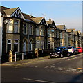
Caradoc Street houses, Cwmcarn
Viewed from Ivor Street. These houses face Cwmcarn Memorial Gardens.
Image: © Jaggery
Taken: 29 Dec 2016
0.01 miles
2
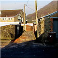
Back lane on the north side of Ivor Street, Cwmcarn
The lane extends for about 170 metres from Ivor Street to Park Street,
between the backs of buildings in Newport Road and Caradoc Street.
Image: © Jaggery
Taken: 29 Dec 2016
0.01 miles
3
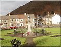
Cwmcarn Memorial Gardens
Viewed from the south side (Ivor Street entrance). The circular sign states
THIS GARDEN IS DEDICATED
TO THE MEMORY OF THOSE WHO
HAVE FALLEN IN WORLD CONFLICTS
PLEASE RESPECT IT AS SUCH
The Welsh language text is below the English text.
Cwmcarn War Memorial http://www.geograph.org.uk/photo/2308735 is in the centre of the gardens.
Image: © Jaggery
Taken: 7 Feb 2011
0.01 miles
4
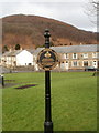
Cwmcarn War Memorial
Located in the centre of Cwmcarn Memorial Park.
The memorial and surrounding railings were Grade II listed in 1998.
Image: © Jaggery
Taken: 7 Feb 2011
0.01 miles
5
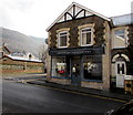
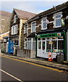
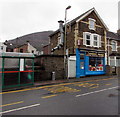
Anderson Photography, Cwmcarn
At 4 Ivor Street, on the corner of Caradoc Street.
Image: © Jaggery
Taken: 29 Dec 2016
0.02 miles
6
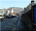
Zigzag markings on Ivor Street, Cwmcarn
Yellow markings define the Keep Clear Zone (no stopping or parking) on the north side of Cwmcarn Primary School.
Image: © Jaggery
Taken: 29 Dec 2016
0.03 miles
7
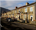
John Street houses, Cwmcarn
This part of John Street is on the north side of Cwmcarn Memorial Park.
Image: © Jaggery
Taken: 29 Dec 2016
0.03 miles
8
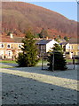
Christmas trees in Cwmcarn Memorial Gardens
Viewed at 11:10am on December 29th 2016 when overnight hoar frost remains
on the grass during a period of mainly sunny and cold anticyclonic weather.
Image: © Jaggery
Taken: 29 Dec 2016
0.03 miles
9
Cwmcarn Fish Bar, Cwmcarn
At 70 Newport Road. Tandoori Haven is on the left.
Image: © Jaggery
Taken: 29 Dec 2016
0.03 miles
10
Tandoori Haven, Cwmcarn
Takeaway behind a Newport Road bus stop and shelter.
Image: © Jaggery
Taken: 7 Jan 2017
0.03 miles