IMAGES TAKEN NEAR TO
Twyncarn Road, NEWPORT, NP11 7DU
Introduction
This page details the photographs taken nearby to Twyncarn Road, NP11 7DU by members of the Geograph project.
The Geograph project started in 2005 with the aim of publishing, organising and preserving representative images for every square kilometre of Great Britain, Ireland and the Isle of Man.

There are currently over 7.5m images from over14,400 individuals and you can help contribute to the project by visiting https://www.geograph.org.uk
Image Map
Images are licensed for reuse under creativecommons.org/licenses/by-sa/2.0
Notes
- Clicking on the map will re-center to the selected point.
- The higher the marker number, the further away the image location is from the centre of the postcode.
Image Listing (146 Images Found)
Images are licensed for reuse under creativecommons.org/licenses/by-sa/2.0
Image
Details
Distance
1
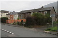
Hawthorn Place, Pontywaun
Row of houses on the east side of the B4591 Twyncarn Road.
Image: © Jaggery
Taken: 17 Dec 2016
0.01 miles
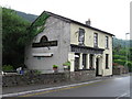
2
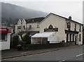
The Philanthropic Inn, Pontywaun
Viewed across the B4591 Twyncarn Road. The name of inn is likely to be a reference to philanthropic societies, which were formed by workers when unions were not permitted. They looked after members and their families when they could not work. In 2016, the inn sign http://www.geograph.org.uk/photo/5228147 depicts two characters from Charles Dickens' Christmas Carol - Tiny Tim sitting on the shoulder of the reformed and now philanthropic Ebenezer Scrooge.
The white tent is a Gala Tent, designed and built in Britain. Best Bets Bookmakers shop http://www.geograph.org.uk/photo/5228141 is on the left.
Image: © Jaggery
Taken: 17 Dec 2016
0.01 miles
3
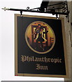
Philanthropic Inn name sign, Pontywaun
Hanging from a wall bracket here. http://www.geograph.org.uk/photo/5228142 The sign depicts two characters from Charles Dickens' Christmas Carol - Tiny Tim sitting on the shoulder of the reformed and now philanthropic Ebenezer Scrooge.
Image: © Jaggery
Taken: 17 Dec 2016
0.01 miles
4
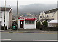
Best Bets Bookmakers, Pontywaun
Licensed betting shop at 38 Twyncarn Road, next door to the Philanthropic Inn, http://www.geograph.org.uk/photo/5228142 out of shot on the right.
Image: © Jaggery
Taken: 17 Dec 2016
0.01 miles
5
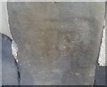
Ordnance Survey Cut Mark
This badly worn OS cut mark can be found on the Philanthropic Public House. It marks a point 81.946m above mean sea level.
Image: © Adrian Dust
Taken: 11 May 2019
0.01 miles
6
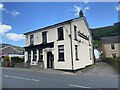
Philanthropic Inn
Public house in Penywaun near Cross Keys.
Image: © Alan Hughes
Taken: 12 Jun 2022
0.01 miles
8
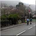
Cycling through Pontywaun
Two Saturday cyclists on the B4591 Twyncarn Road head towards Crosskeys.
Image: © Jaggery
Taken: 17 Dec 2016
0.03 miles
9
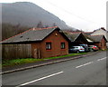
Semi-detached bungalows, Twyncarn Road, Penywaun
Located between Twyncarn Road and the disused Monmouthshire and Brecon canal (Crumlin Arm).
Image: © Jaggery
Taken: 17 Dec 2016
0.03 miles
10
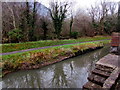
Reflections on the canal, Pontywaun
Part of the disused Monmouthshire and Brecon canal (Crumlin Arm).
Image: © Jaggery
Taken: 17 Dec 2016
0.03 miles