IMAGES TAKEN NEAR TO
Park Place, NEWPORT, NP11 7DB
Introduction
This page details the photographs taken nearby to Park Place, NP11 7DB by members of the Geograph project.
The Geograph project started in 2005 with the aim of publishing, organising and preserving representative images for every square kilometre of Great Britain, Ireland and the Isle of Man.

There are currently over 7.5m images from over14,400 individuals and you can help contribute to the project by visiting https://www.geograph.org.uk
Image Map
Images are licensed for reuse under creativecommons.org/licenses/by-sa/2.0
Notes
- Clicking on the map will re-center to the selected point.
- The higher the marker number, the further away the image location is from the centre of the postcode.
Image Listing (166 Images Found)
Images are licensed for reuse under creativecommons.org/licenses/by-sa/2.0
Image
Details
Distance
1
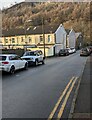
Park Place towards Park Street, Crosskeys
Looking across Park Place towards the backs of Park Street houses.
Image: © Jaggery
Taken: 20 Dec 2022
0.01 miles
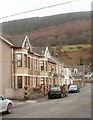
2
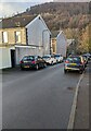
On-street parking, Park Place, Crosskeys
The cars on the left are parked on the approach to the Park Street junction.
Image: © Jaggery
Taken: 20 Dec 2022
0.01 miles
3
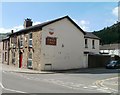
Eagle Inn, Crosskeys
On the corner of High Street and Park Place.
Image: © Jaggery
Taken: 16 Aug 2010
0.02 miles
4
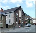
Crosskeys Methodist Church
Located on High Street, a few metres north of Park Place. The church dates from 1875.
Image: © Jaggery
Taken: 16 Aug 2010
0.02 miles
5
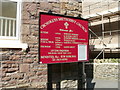
Crosskeys Methodist Church board
The church http://www.geograph.org.uk/photo/2016513 is on High Street Crosskeys.
Image: © Jaggery
Taken: 16 Aug 2010
0.02 miles
6
Park Place, Crosskeys
Looking east towards High Street from opposite the corner of Park View.
Image: © Jaggery
Taken: 7 Feb 2011
0.02 miles
7
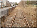
Overgrown railway line, Crosskeys
The view north from underneath a disused footbridge http://www.geograph.org.uk/photo/2016469 on the eastern side of High Street.
The track in the opposite direction is even more overgrown. http://www.geograph.org.uk/photo/2262155
Image: © Jaggery
Taken: 7 Feb 2011
0.02 miles
8
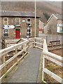
Footbridge across the track, High Street, Crosskeys
To replace a disused metal bridge http://www.geograph.org.uk/photo/2016469 above a disused single-track railway line, a wooden structure crosses from Halls Road to High Street at track level.
On the far side of the road is the Eagle Inn http://www.geograph.org.uk/photo/2016478
Image: © Jaggery
Taken: 7 Feb 2011
0.02 miles
9
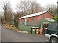
Corrugated metal building, Halls Road, Crosskeys
The building on the east side of Halls Road is shown on one map as a hall, but there were nothing at the site to show its current usage, if any.
Image: © Jaggery
Taken: 7 Feb 2011
0.02 miles
10
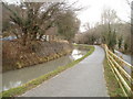
Former Monmouthshire & Brecon canal and towpath, Crosskeys
This section of the disused canal is between Mount Pleasant Terrace on the left and Halls Road.
Image: © Jaggery
Taken: 7 Feb 2011
0.02 miles