IMAGES TAKEN NEAR TO
The Meadows, Cromwell Road, NEWPORT, NP11 7AR
Introduction
This page details the photographs taken nearby to The Meadows, Cromwell Road, NP11 7AR by members of the Geograph project.
The Geograph project started in 2005 with the aim of publishing, organising and preserving representative images for every square kilometre of Great Britain, Ireland and the Isle of Man.

There are currently over 7.5m images from over14,400 individuals and you can help contribute to the project by visiting https://www.geograph.org.uk
Image Map
Images are licensed for reuse under creativecommons.org/licenses/by-sa/2.0
Notes
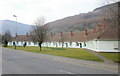
- Clicking on the map will re-center to the selected point.
- The higher the marker number, the further away the image location is from the centre of the postcode.
Image Listing (65 Images Found)
Images are licensed for reuse under creativecommons.org/licenses/by-sa/2.0
Image
Details
Distance
1
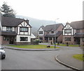
The Meadows, Crosskeys
Modern houses in a short cul-de-sac on the south side of Medart Place.
Image: © Jaggery
Taken: 11 Mar 2010
0.01 miles
2
Medart Place houses, Crosskeys
Houses on the north side of Medart Place, Crosskeys, just beyond the edge of Risca.
Image: © Jaggery
Taken: 11 Mar 2010
0.01 miles
3
Welcome to Crosskeys
The sign marks the boundary of Crosskeys and Risca. On crossing the border, Cromwell Road, Risca is renamed Medart Place, Crosskeys.
Image: © Jaggery
Taken: 11 Mar 2010
0.01 miles
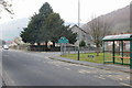
4
Outdated bus stop sign, Medart Place, Crosskeys
In May 2018, the bus stop sign near the corner of Blackvein Road shows three services operated by Glyn Williams. In 2006, the family firm sold their shares in Crosskeys Coach Hire, which traded as Glyn Williams Travel, to Red and White Services, a subsidiary of Stagecoach, who now operate the buses stopping here.
The white arrow on the small blue label on the bus stop pole points left towards Blackvein Road for National Cycle Network Route 47, a mainly inland route from the city of Newport to Fishguard via Neath and Carmarthen.
Image: © Jaggery
Taken: 23 May 2018
0.01 miles
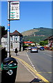
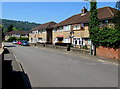
5
Medart Place houses, Crosskeys
On the north side of the B4591 Medart Place viewed from near the corner of Blackvein Road.
Image: © Jaggery
Taken: 23 May 2018
0.04 miles
6
Blackvein Road semis, Crosskeys
Semi-detached houses on the approach to the Waunfawr Gardens junction. https://www.geograph.org.uk/photo/5785098
Image: © Jaggery
Taken: 23 May 2018
0.05 miles
7
NE along Blackvein Road, Crosskeys
Looking to the northeast across New Park Road along Blackvein Road towards Medart Place.
The grey back of the Crosskeys boundary sign https://www.geograph.org.uk/photo/5785145 is on the left.
Image: © Jaggery
Taken: 23 May 2018
0.05 miles
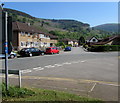
8
New Park Road enters Risca from Crosskeys
The Risca/Rhisga boundary sign https://www.geograph.org.uk/photo/5785130 is on the right.
Image: © Jaggery
Taken: 23 May 2018
0.06 miles
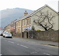
9
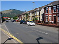
Cromwell Road Bungalows, Risca
This elegant crescent of bungalows is located on the north side of Cromwell Road, at the western end of Risca : Crosskeys is a few metres beyond the left edge of the photo.
Image: © Jaggery
Taken: 11 Mar 2010
0.06 miles
10
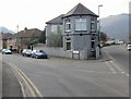
Corner of Medart Place and Blackvein Road, Crosskeys
I haven't yet found out if the front part of the house on the corner has any connection with Black Vein Colliery (a former lodge, perhaps?)
Blackvein Road on the left formerly led to Black Vein Colliery. It was worked fully between 1841 and 1888 until the North Risca Colliery (Crosskeys) was opened. It then operated intermittently until the 1920s.
Black Vein was extremely gaseous in some sections, and became known as the "Death Pit" because of the number of explosions. Between 1846 and 1860 explosions killed 194 miners. The deadliest explosion was in December 1860 when 146 were killed.
Image: © Jaggery
Taken: 11 Mar 2010
0.06 miles