IMAGES TAKEN NEAR TO
Waunfawr Gardens, NEWPORT, NP11 7AJ
Introduction
This page details the photographs taken nearby to Waunfawr Gardens, NP11 7AJ by members of the Geograph project.
The Geograph project started in 2005 with the aim of publishing, organising and preserving representative images for every square kilometre of Great Britain, Ireland and the Isle of Man.

There are currently over 7.5m images from over14,400 individuals and you can help contribute to the project by visiting https://www.geograph.org.uk
Image Map
Images are licensed for reuse under creativecommons.org/licenses/by-sa/2.0
Notes
- Clicking on the map will re-center to the selected point.
- The higher the marker number, the further away the image location is from the centre of the postcode.
Image Listing (72 Images Found)
Images are licensed for reuse under creativecommons.org/licenses/by-sa/2.0
Image
Details
Distance
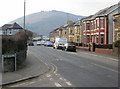
1
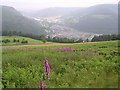
Crosskeys, Pontywaun and Ebbw Valley
Looking North into Ebbw Vale from the slopes of Mynydd Machen. The A 467 is visible curving along the left of the valley below Craig y Pandy
Image: © Richard Greenwood
Taken: 29 Jun 2005
0.02 miles
2
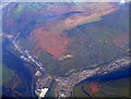
Crosskeys from the air
Viewed from a Bristol bound flight from Glasgow.
Image: © Thomas Nugent
Taken: 11 Oct 2010
0.02 miles
3
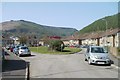
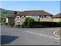
Waunfawr Gardens, Crosskeys
The houses in Waunfawr Gardens are arranged around an elongated semicircle on the west side of Black Vein Road.
Image: © Jaggery
Taken: 10 Apr 2011
0.02 miles
4
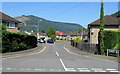
West along Waunfawr Gardens, Crosskeys
The sign on the corner of Blackvein Road shows that Waunfawr Gardens is not a through route.
The eastern edge of Coleg Gwent Crosskeys Campus is behind the houses in the background.
Image: © Jaggery
Taken: 23 May 2018
0.03 miles
5
Mynydd Y Lan in the distance, Medart Place, Crosskeys
Medart Place (B4591) heads away from the turning for The Meadows. http://www.geograph.org.uk/photo/1759297
In the distance is Mynydd Y Lan (385 metres or 1,263 feet).
Image: © Jaggery
Taken: 11 Mar 2010
0.04 miles
6
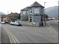
Corner of Medart Place and Blackvein Road, Crosskeys
I haven't yet found out if the front part of the house on the corner has any connection with Black Vein Colliery (a former lodge, perhaps?)
Blackvein Road on the left formerly led to Black Vein Colliery. It was worked fully between 1841 and 1888 until the North Risca Colliery (Crosskeys) was opened. It then operated intermittently until the 1920s.
Black Vein was extremely gaseous in some sections, and became known as the "Death Pit" because of the number of explosions. Between 1846 and 1860 explosions killed 194 miners. The deadliest explosion was in December 1860 when 146 were killed.
Image: © Jaggery
Taken: 11 Mar 2010
0.04 miles
7
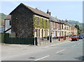
Ivy-clad houses, Medart Place, Crosskeys
A row of semi-detached houses on the north side of the B4591. The houses in the middle of the row face Black Vein Road. http://www.geograph.org.uk/photo/1759685
Image: © Jaggery
Taken: 10 Apr 2011
0.04 miles
8
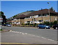
Waunfawr Park Road housing, Crosskeys
The eight satellite dishes in view and the side door on the right suggest
that what looks at first glance like four semi-detached houses are eight flats.
Image: © Jaggery
Taken: 23 May 2018
0.04 miles
9
Semis on a Crosskeys corner
Semi-detached houses on the corner of Blackvein Road and Waunfawr Gardens.
Image: © Jaggery
Taken: 23 May 2018
0.04 miles
10
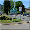
Crosskeys boundary sign near Waunfawr Park
The sign suggests that Crosskeys does not have a different name in Welsh.
The boundary sign https://www.geograph.org.uk/photo/5785130 behind the camera shows that Risca is Rhisga in Welsh.
Image: © Jaggery
Taken: 23 May 2018
0.05 miles