IMAGES TAKEN NEAR TO
Cromwell Road, NEWPORT, NP11 7AF
Introduction
This page details the photographs taken nearby to Cromwell Road, NP11 7AF by members of the Geograph project.
The Geograph project started in 2005 with the aim of publishing, organising and preserving representative images for every square kilometre of Great Britain, Ireland and the Isle of Man.

There are currently over 7.5m images from over14,400 individuals and you can help contribute to the project by visiting https://www.geograph.org.uk
Image Map
Images are licensed for reuse under creativecommons.org/licenses/by-sa/2.0
Notes
- Clicking on the map will re-center to the selected point.
- The higher the marker number, the further away the image location is from the centre of the postcode.
Image Listing (68 Images Found)
Images are licensed for reuse under creativecommons.org/licenses/by-sa/2.0
Image
Details
Distance
1
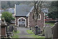
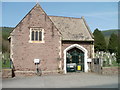
Chapel, Risca Old Cemetery
Restored chapel, built in 1886 in the Gothic style. The ornamental gates open onto Cromwell Road.
Image: © M J Roscoe
Taken: 2 Nov 2017
0.02 miles
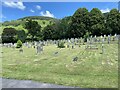
3
Risca Old Cemetery
The cemetery occupies a 1.7 hectare (4 acres) site on the north side of Cromwell Road. It opened in 1888. New graves are no longer available.
In the distance, at the left edge of the photo, is the cemetery chapel. http://www.geograph.org.uk/photo/1759269
Image: © Jaggery
Taken: 11 Mar 2010
0.03 miles
4
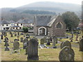
Chapel, Risca Old Cemetery
Located adjacent to Cromwell Road in the central part of the cemetery. http://www.geograph.org.uk/photo/1759257
Image: © Jaggery
Taken: 11 Mar 2010
0.04 miles
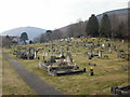
5
Former chapel, Risca Old Cemetery
Viewed across Cromwell Road (B4591). The date on the gates is 1886. There are no new graves available in Risca Old Cemetery. Risca district burials are now in Danygraig Cemetery on the western edge of the town.
Image: © Jaggery
Taken: 10 Apr 2011
0.04 miles
6
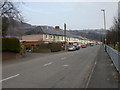
Houses, eastern New Park Road, Risca
Looking east in the direction of Raglan Street. The houses are on the north side of New Park Road. Rugby pitches http://www.geograph.org.uk/photo/1759762 occupy the south side.
Image: © Jaggery
Taken: 11 Mar 2010
0.06 miles
7
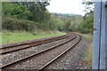
Ebbw Valley Railway, Risca
Railway line east towards Risca Station, from Medart Street level crossing Image
Image: © M J Roscoe
Taken: 20 Oct 2017
0.06 miles
8

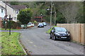
Medart Street (2), Risca
Viewed from the level crossing, an opposite view to Image This residential street is a cycle route and part of the Raven Walk.
Image: © M J Roscoe
Taken: 2 Nov 2017
0.07 miles
9
Medart Street, Risca
Residential cul-de-sac, part of the Raven Walk, leading to level crossing.
Image: © M J Roscoe
Taken: 20 Oct 2017
0.08 miles
10
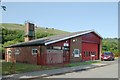
Risca Fire Station
Risca Fire Station, New Park Road, Risca - part of South Wales Fire & Rescue Service
Image: © Kevin Hale
Taken: 4 Jun 2007
0.08 miles