IMAGES TAKEN NEAR TO
Raglan Street, NEWPORT, NP11 7AA
Introduction
This page details the photographs taken nearby to Raglan Street, NP11 7AA by members of the Geograph project.
The Geograph project started in 2005 with the aim of publishing, organising and preserving representative images for every square kilometre of Great Britain, Ireland and the Isle of Man.

There are currently over 7.5m images from over14,400 individuals and you can help contribute to the project by visiting https://www.geograph.org.uk
Image Map
Images are licensed for reuse under creativecommons.org/licenses/by-sa/2.0
Notes
- Clicking on the map will re-center to the selected point.
- The higher the marker number, the further away the image location is from the centre of the postcode.
Image Listing (96 Images Found)
Images are licensed for reuse under creativecommons.org/licenses/by-sa/2.0
Image
Details
Distance
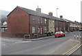
1
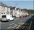
Cromwell Road houses, Risca
Houses on the north side of the B4591, between the SE corner of Risca Old Cemetery http://www.geograph.org.uk/photo/1759257 and the left turn ahead for Nant-y-garn.
Image: © Jaggery
Taken: 10 Apr 2011
0.02 miles
2
Western Valley Models, Risca
1 Crescent Road, on the corner of Cromwell Road.
Suppliers of remote control model cars, planes, helicopters and boats ; model kit cars, motorcycles, planes, military ; train sets and accessories ; modelling tools and accessories.
Image: © Jaggery
Taken: 11 Mar 2010
0.02 miles
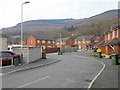
3
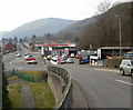
Cromwell Road and lower Darran Road, Risca
The view west from the lower part of Darran Road. In the middle distance, Cromwell Road heads towards Crosskeys. On the right are three motor trade premises :
Phil Harvey Tyres of Risca.
Trustworthy Motors.
Esso filling station.
Image: © Jaggery
Taken: 11 Mar 2010
0.02 miles
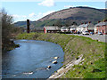
4
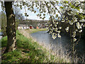
River Ebbw looking downriver
Crescent Road is on the left.
Image: © Robin Drayton
Taken: 5 Apr 2008
0.04 miles
5
Cromwell Road houses, Risca
Houses on the south side of Cromwell Road adjacent to the corner of Crescent Road.
Image: © Jaggery
Taken: 11 Mar 2010
0.05 miles
6
Nant Y Garn, Risca
Houses built c2005. Nant Y Garn connects with the north side of Cromwell Road.
Image: © Jaggery
Taken: 11 Mar 2010
0.06 miles
7
River Ebbw looking upriver
Image: © Robin Drayton
Taken: 5 Apr 2008
0.06 miles
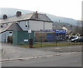
8
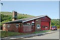
Risca Fire Station
Risca Fire Station, New Park Road, Risca - part of South Wales Fire & Rescue Service
Image: © Kevin Hale
Taken: 4 Jun 2007
0.07 miles
9
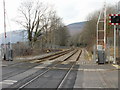
Railway lines heading northwest from Lime Kiln level crossing, Risca
The next station is this direction, on the Cardiff Central toEbbw Vale Parkway route, is Crosskeys, nearly 2 kilometres distant. Viewed from Lime Kiln level crossing. http://www.geograph.org.uk/photo/1759011
The view in the opposite direction. http://www.geograph.org.uk/photo/1759067
Image: © Jaggery
Taken: 11 Mar 2010
0.08 miles
10
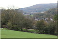
View across canal towards Ty Darran
View on an overcast morning from the Cwm Byr burial ground across the Monmouthshire & Brecon Canal over the Ebbw Valley.
Image: © M J Roscoe
Taken: 2 Nov 2017
0.08 miles