IMAGES TAKEN NEAR TO
Gelli Close, NEWPORT, NP11 6PS
Introduction
This page details the photographs taken nearby to Gelli Close, NP11 6PS by members of the Geograph project.
The Geograph project started in 2005 with the aim of publishing, organising and preserving representative images for every square kilometre of Great Britain, Ireland and the Isle of Man.

There are currently over 7.5m images from over14,400 individuals and you can help contribute to the project by visiting https://www.geograph.org.uk
Image Map
Images are licensed for reuse under creativecommons.org/licenses/by-sa/2.0
Notes
- Clicking on the map will re-center to the selected point.
- The higher the marker number, the further away the image location is from the centre of the postcode.
Image Listing (39 Images Found)
Images are licensed for reuse under creativecommons.org/licenses/by-sa/2.0
Image
Details
Distance
1
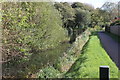
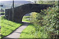
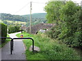
Monmouthshire & Brecon Canal south east of Gelli Avenue
Disused section of canal's Crumlin Arm and towpath (cycle route)
Image: © M J Roscoe
Taken: 20 Oct 2017
0.02 miles
2
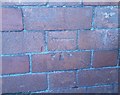
Ordnance Survey Cut Mark
This OS cut mark can be found on No19 Gelli Crescent. It marks a point 76.690m above mean sea level.
Image: © Adrian Dust
Taken: 11 May 2019
0.03 miles
3
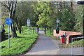
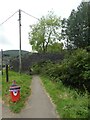
Canalside path west of Gelli Avenue, Risca
Foot and cycle lane alongside the disused Crumlin Arm of the Monmouthshire & Brecon Canal.
Image: © M J Roscoe
Taken: 20 Oct 2017
0.04 miles
4
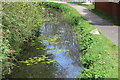
Water lilies in canal, Crumlin Arm
Disused canal east of Moriah Hill Bridge Image
Image: © M J Roscoe
Taken: 29 Apr 2023
0.14 miles
5
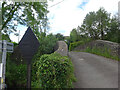
Moriah Hill bridge, Monmouthshire & Brecon Canal, Risca
Stone bridge, grade II listed, over disused Crumlin Arm of canal.
Image: © M J Roscoe
Taken: 20 Oct 2017
0.16 miles
6
Moriah Hill bridge over Monmouthshire and Brecon Canal, Risca
Image: © David Smith
Taken: 25 Sep 2021
0.16 miles
7
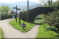
Moriah Hill Bridge, Crumlin Arm
Elliptical stone arch bridge over disused canal; the towpath carries NCR 47, Celtic Trail.
Image: © M J Roscoe
Taken: 29 Apr 2023
0.16 miles
8
Weight limit, MonBrec Crumlin Arm
GWR weight limit sign on the MonBrec canal. From the GWR ownership era.
Milestone Society ID: TBC
Image: © Mr Red
Taken: 10 Jun 2021
0.16 miles
9
Monmouthshire & Brecon Canal (Crumlin Arm) near Risca
Image: © Gareth James
Taken: 25 Aug 2013
0.16 miles
10
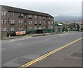
Four-storey building, Elm Drive, Risca
Located between Thistle Way and Aster Close.
Flats are on the top three floors.
Below road level, shops are on the ground floor.
Image: © Jaggery
Taken: 26 Jun 2019
0.16 miles