IMAGES TAKEN NEAR TO
Thistle Way, NEWPORT, NP11 6PL
Introduction
This page details the photographs taken nearby to Thistle Way, NP11 6PL by members of the Geograph project.
The Geograph project started in 2005 with the aim of publishing, organising and preserving representative images for every square kilometre of Great Britain, Ireland and the Isle of Man.

There are currently over 7.5m images from over14,400 individuals and you can help contribute to the project by visiting https://www.geograph.org.uk
Image Map
Images are licensed for reuse under creativecommons.org/licenses/by-sa/2.0
Notes
- Clicking on the map will re-center to the selected point.
- The higher the marker number, the further away the image location is from the centre of the postcode.
Image Listing (53 Images Found)
Images are licensed for reuse under creativecommons.org/licenses/by-sa/2.0
Image
Details
Distance
1
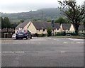
Thistle Way, Risca
Thistle Way descends from Elm Drive.
Image: © Jaggery
Taken: 26 Jun 2019
0.05 miles
2
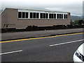
St David's Church, Risca
The Elm Drive side of the Methodist church on the corner of Thistle Way.
The church is also used by a Church in Wales congregation.
Image: © Jaggery
Taken: 26 Jun 2019
0.06 miles
3
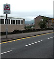
Warning sign - Patrol/Hebryngwr, Elm Drive, Risca
English/Welsh sign near Ty Sign Primary School.
Image: © Jaggery
Taken: 26 Jun 2019
0.06 miles
4
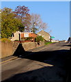
Ascent towards Ty Sign
Lower Wyndham Terrace ascends towards the white-on-green Ty Sign boundary sign.
Ty Sign is a large residential area on high ground in the north of Risca.
Image: © Jaggery
Taken: 22 Nov 2018
0.06 miles
5
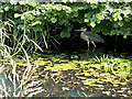
Lurking in the shadows
A heron takes cover away from the canal towpath.
Image: © Alan Hughes
Taken: 15 Jul 2021
0.07 miles
6
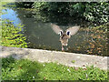
We have lift-off!
A duck launching himself into the Monmouthshire and Brecon canal.
Image: © Alan Hughes
Taken: 15 Jul 2021
0.07 miles
7
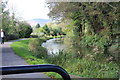
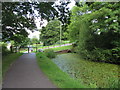
Monmouthshire & Brecon Canal north west of Thistle Way
Disused Crumlin Arm of the canal and towpath (cycle route); the canal is in a culvert under Thistle Way.
Image: © M J Roscoe
Taken: 20 Oct 2017
0.08 miles
8
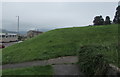
Southeast edge of a grassy bank, Elm Drive, Risca
Image: © Jaggery
Taken: 26 Jun 2019
0.08 miles
9
Monmouthshire & Brecon Canal (Crumlin Arm) near Risca
Image: © Gareth James
Taken: 25 Aug 2013
0.08 miles
10
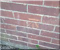
Ordnance Survey Cut Mark
This OS cut mark can be found on No107 Elm Drive. It marks a point 112.200m above mean sea level.
Image: © Adrian Dust
Taken: 11 May 2019
0.08 miles