IMAGES TAKEN NEAR TO
Ty Isaf Park Avenue, NEWPORT, NP11 6NJ
Introduction
This page details the photographs taken nearby to Ty Isaf Park Avenue, NP11 6NJ by members of the Geograph project.
The Geograph project started in 2005 with the aim of publishing, organising and preserving representative images for every square kilometre of Great Britain, Ireland and the Isle of Man.

There are currently over 7.5m images from over14,400 individuals and you can help contribute to the project by visiting https://www.geograph.org.uk
Image Map (Loading...)


Getting Data...Please wait
Leaflet Map data © OpenStreetMap
Images are licensed for reuse under creativecommons.org/licenses/by-sa/2.0
Notes
- Clicking on the map will re-center to the selected point.
- The higher the marker number, the further away the image location is from the centre of the postcode.
Image Listing (60 Images Found)
Images are licensed for reuse under creativecommons.org/licenses/by-sa/2.0
Image
Details
Distance
1
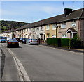
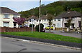
West along Ty-Isaf Park Avenue, Pontymister
Viewed from near the Ty-Isaf Park Road and Tyn-y-cwm Road junctions.
Image: © Jaggery
Taken: 30 Apr 2018
0.03 miles
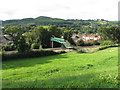
2
Railway footbridge, Pontymister
Viewed from Herbert Avenue. The footbridge crosses the Cardiff to Ebbw Vale railway line less than a kilometre east of Risca and Pontymister station. On the far side of the bridge, a path leads to Ty-Isaf Park Road.
Image: © Jaggery
Taken: 11 Mar 2010
0.06 miles
3
Footbridge across the railway near Risca
Image: © Gareth James
Taken: 25 Aug 2013
0.07 miles
4
Six rooftop solar panels on a Pontymister corner
On the roof of a house on the corner of Ty-Isaf Park Avenue and Ty-Isaf Park Circle.
Image: © Jaggery
Taken: 30 Apr 2018
0.07 miles
5
No ball games on this grass triangle, Pontymister
The sign on the grass triangle at the Ty-Isaf Park Avenue/Ty-Isaf Park Road junction https://www.geograph.org.uk/photo/5757162
shows No Ball Games and its Welsh equivalent.
Image: © Jaggery
Taken: 30 Apr 2018
0.07 miles
6

Meadow Crescent, Pontymister
From the corner of Newport Road along Meadow Crescent towards Ty-Isaf Park Avenue.
Pricedown Stores, https://www.geograph.org.uk/photo/5757305 a Premier convenience store, is on the left.
Image: © Jaggery
Taken: 30 Apr 2018
0.08 miles
7
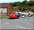
Royal Mail van on a Pontymister corner
Parked on the corner of Ty-Isaf Park Avenue and Ty-Isaf Park Circle while its driver delivers letters and small parcels to nearby houses.
Image: © Jaggery
Taken: 30 Apr 2018
0.08 miles
8
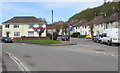
Junction at the NW end of Tyn-y-cwm Road, Pontymister
Ty-Isaf Park Avenue is on the left, Ty-Isaf Park Road is on the right.
Image: © Jaggery
Taken: 30 Apr 2018
0.08 miles
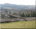
9
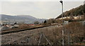
Curve in the railway tracks alongside Herbert Avenue, Pontymister
In the distance, the tracks curve to the left, on the way to Risca and Pontymister railway station, about 1 kilometre distant. The houses on the right are on Herbert Avenue.
Image: © Jaggery
Taken: 11 Mar 2010
0.08 miles
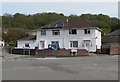
10
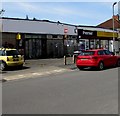
Pricedown Stores, Meadow Crescent, Pontymister
A Premier convenience store viewed in April 2018.
A July 2012 Google Earth Street View shows a Londis convenience store here.
Image: © Jaggery
Taken: 30 Apr 2018
0.09 miles