IMAGES TAKEN NEAR TO
Springfield Road, NEWPORT, NP11 6LZ
Introduction
This page details the photographs taken nearby to Springfield Road, NP11 6LZ by members of the Geograph project.
The Geograph project started in 2005 with the aim of publishing, organising and preserving representative images for every square kilometre of Great Britain, Ireland and the Isle of Man.

There are currently over 7.5m images from over14,400 individuals and you can help contribute to the project by visiting https://www.geograph.org.uk
Image Map
Images are licensed for reuse under creativecommons.org/licenses/by-sa/2.0
Notes
- Clicking on the map will re-center to the selected point.
- The higher the marker number, the further away the image location is from the centre of the postcode.
Image Listing (100 Images Found)
Images are licensed for reuse under creativecommons.org/licenses/by-sa/2.0
Image
Details
Distance
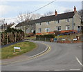
1
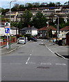
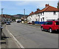
Traffic calming on Springfield Road, Pontymister
Traffic on the camera side has priority through the one-lane section of road ahead.
Image: © Jaggery
Taken: 30 Apr 2018
0.04 miles
2
Looking down Channel View, Pontymister
Viewed from opposite the turning for Severn Close.
Image: © Jaggery
Taken: 11 Mar 2010
0.05 miles
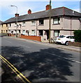
3
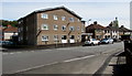
Three-storey flats, Ty Isaf Park Avenue, Pontymister
On the corner of Springfield Road.
Image: © Jaggery
Taken: 30 Apr 2018
0.05 miles
4
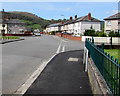
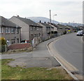
Two junctions, Ty Isaf Park Avenue, Pontymister
The Ty Isaf Crescent junction is on the left.
The Springfield Road junction is on the right.
Image: © Jaggery
Taken: 30 Apr 2018
0.06 miles
5
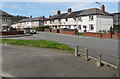
Grass semicircle and concrete posts on a Pontymister corner
On the corner of Ty Isaf Crescent and Springfield Road.
Image: © Jaggery
Taken: 30 Apr 2018
0.06 miles
6
WNW along Ty-Isaf Park Avenue, Pontymister
Looking to the west northwest along Ty-Isaf Park Avenue towards Springfield Road and Ty-Isaf Crescent.
Image: © Jaggery
Taken: 30 Apr 2018
0.08 miles
7
Channel View, Pontymister
Houses on the south side of Channel View, near the western end of Herbert Avenue. In the distance is Mynydd Machen Image
Image: © Jaggery
Taken: 11 Mar 2010
0.10 miles
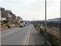
8
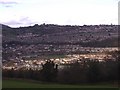
The sun shines on Pontymister
View from Upper Ochrwyth
Image: © Roger Cornfoot
Taken: 1 Mar 2007
0.10 miles
9
Severn Close, Risca
It's often unclear exactly where Pontymister ends and Risca begins. Some sources state that Severn Close is in Risca, others say Pontymister. It's possible that both are correct, for Severn Close fans out in a V-shaped pattern from Channel View. Houses 1-26 are along the left (west) arm of the close, part of which is seen here. Houses 27-38 are beyond the right edge of the photo.
Image: © Jaggery
Taken: 11 Mar 2010
0.10 miles
10
Row of houses, Newport Road, Pontymister
On the north side of the B4591 Newport Road.
Image: © Jaggery
Taken: 30 Apr 2018
0.11 miles