IMAGES TAKEN NEAR TO
Mill Street, NEWPORT, NP11 6LG
Introduction
This page details the photographs taken nearby to Mill Street, NP11 6LG by members of the Geograph project.
The Geograph project started in 2005 with the aim of publishing, organising and preserving representative images for every square kilometre of Great Britain, Ireland and the Isle of Man.

There are currently over 7.5m images from over14,400 individuals and you can help contribute to the project by visiting https://www.geograph.org.uk
Image Map
Images are licensed for reuse under creativecommons.org/licenses/by-sa/2.0
Notes
- Clicking on the map will re-center to the selected point.
- The higher the marker number, the further away the image location is from the centre of the postcode.
Image Listing (143 Images Found)
Images are licensed for reuse under creativecommons.org/licenses/by-sa/2.0
Image
Details
Distance
1
Up Mill Street, Pontymister
Mill Street ascends towards Foundry Road and Channel View.
The Masons Arms pub https://www.geograph.org.uk/photo/5758342 is near the camera.
Image: © Jaggery
Taken: 1 May 2018
0.01 miles
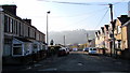
2
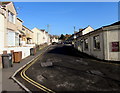
Northern end of Mill Street, Risca
Mill Street ascends towards crossroads at the junctions of Foundry Road, Channel View and Lower Wyndham Terrace. Double yellow lines indicate no parking at any time.
Image: © Jaggery
Taken: 22 Nov 2018
0.01 miles
3

Crossroads mini-roundabout in Risca
In the middle of the crossroads of Mill Street, Foundry Road, Channel View and Lower Wyndham Terrace.
Image: © Jaggery
Taken: 22 Nov 2018
0.02 miles
4
West along Foundry Road, Risca
The sign on the right shows that Foundry Road leads to Millbrook Cottages.
The sign on the left shows that Foundry Road is Heol y Ffowndri in Welsh.
Image: © Jaggery
Taken: 22 Nov 2018
0.02 miles
5
BT phonebox, Foundry Road, Risca
Near the corner of Lower Wyndham Terrace.
Image: © Jaggery
Taken: 22 Nov 2018
0.02 miles
6
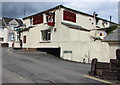
Masons Arms, Mill Terrace, Pontymister
Pub located near Risca & Pontymister railway station. https://www.geograph.org.uk/photo/5758350 to the pub name sign.
Image: © Jaggery
Taken: 1 May 2018
0.03 miles
7
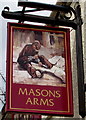
Masons Arms name sign, Mill Terrace, Pontymister
Hanging from a wall bracket here. https://www.geograph.org.uk/photo/5758342
Image: © Jaggery
Taken: 1 May 2018
0.03 miles
8
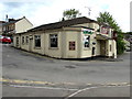
West side of the Masons Arms, Pontymister
Pub on the corner of Mill Street and Mill Terrace. https://www.geograph.org.uk/photo/5758350 to the pub name sign on the right.
Image: © Jaggery
Taken: 1 May 2018
0.03 miles
9
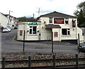
South side of the Masons Arms, Pontymister
Pub viewed from Risca & Pontymister railway station car park. https://www.geograph.org.uk/photo/5758350 to the name sign on the right.
Image: © Jaggery
Taken: 1 May 2018
0.03 miles
10
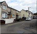
Housing variety, Mill Street, Risca
One style of houses on the west side, another style on the east side.
Image: © Jaggery
Taken: 22 Nov 2018
0.03 miles