IMAGES TAKEN NEAR TO
Tanybryn, NEWPORT, NP11 6JR
Introduction
This page details the photographs taken nearby to Tanybryn, NP11 6JR by members of the Geograph project.
The Geograph project started in 2005 with the aim of publishing, organising and preserving representative images for every square kilometre of Great Britain, Ireland and the Isle of Man.

There are currently over 7.5m images from over14,400 individuals and you can help contribute to the project by visiting https://www.geograph.org.uk
Image Map
Images are licensed for reuse under creativecommons.org/licenses/by-sa/2.0
Notes
- Clicking on the map will re-center to the selected point.
- The higher the marker number, the further away the image location is from the centre of the postcode.
Image Listing (56 Images Found)
Images are licensed for reuse under creativecommons.org/licenses/by-sa/2.0
Image
Details
Distance
1
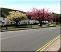
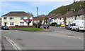
Late April blossom in Pontymister
Viewed across the B4591 Newport Road on April 30th 2018.
Image: © Jaggery
Taken: 30 Apr 2018
0.06 miles
2
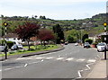
Zebra crossing, Newport Road, Pontymister
Although Belisha beacons had marked pedestrian crossings in the UK from 1934, it was not until 1951 that the now familiar black and white stripes stretching across the width of the road were officially introduced. Previously, there were only metal studs across the road surface.
Image: © Jaggery
Taken: 30 Apr 2018
0.07 miles
3
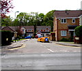
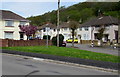
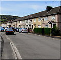
Maple Gardens, Pontymister
Cul-de-sac on the south side of the B4591 Newport Road.
The houses in the background are on the north bank of the Ebbw River.
Image: © Jaggery
Taken: 30 Apr 2018
0.10 miles
4
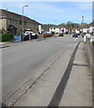
Tyn-y-cwm Road, Pontymister
Viewed from the corner of the B4591 Newport Road.
Image: © Jaggery
Taken: 30 Apr 2018
0.11 miles
5
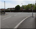
Junction at the NW end of Tyn-y-cwm Road, Pontymister
Ty-Isaf Park Avenue is on the left, Ty-Isaf Park Road is on the right.
Image: © Jaggery
Taken: 30 Apr 2018
0.12 miles
6
No ball games on this grass triangle, Pontymister
The sign on the grass triangle at the Ty-Isaf Park Avenue/Ty-Isaf Park Road junction https://www.geograph.org.uk/photo/5757162
shows No Ball Games and its Welsh equivalent.
Image: © Jaggery
Taken: 30 Apr 2018
0.12 miles
7
Mandatory left turn at the SE end of Meadow Crescent, Pontymister
No Right Turn signs are on the approach to the B4591 Newport Road.
A few seconds after I'd taken this photo, a van turned right into Newport Road...
Image: © Jaggery
Taken: 30 Apr 2018
0.14 miles
8
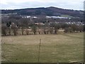
View from the towpath
A view across the valley from the towpath of the Monmouthshire & Brecon Canal.
Rogerstone Park Industrial Estate is visible below Coed Mawr.
Image: © Michael Dibb
Taken: 10 Mar 2010
0.14 miles
9
West along Ty-Isaf Park Avenue, Pontymister
Viewed from near the Ty-Isaf Park Road and Tyn-y-cwm Road junctions.
Image: © Jaggery
Taken: 30 Apr 2018
0.14 miles
10
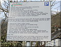
Caerphilly County Borough Council's parking rules
The notice is on display at the car park in Herbert Avenue, Pontymister.
Among the many conditions of parking here is one that you must use it only for parking. Activities specifically excluded are :
Reckless driving, loitering, music, eating, drinking, skateboarding, skating, ball games, trading, camping, sleeping, cooking, washing of vehicles or vehicle repair (except in emergency).
The car park is unmanned, so presumably occasional visits are made by council employees to ensure that the rules are being followed.
Image: © Jaggery
Taken: 11 Mar 2010
0.14 miles